Call or Text: +1 (208) 425-2990
Email: Sales@DroneSprayPro.com
1
/
of
1
Drone Spray Pro
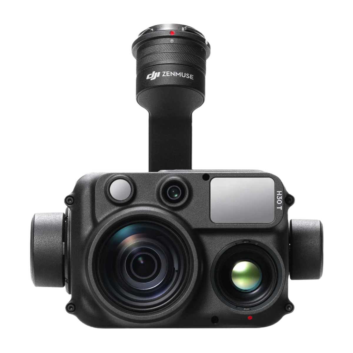
DJI Zenmuse H30T
DJI Zenmuse H30T
Regular price
$9,799.00 USD
Regular price
$11,150.00 USD
Sale price
$9,799.00 USD
Unit price
/
per
Shipping calculated at checkout.
Couldn't load pickup availability
DJI Zenmuse H30T – All-in-One Multi-Sensor Aerial Payload
The DJI Zenmuse H30T is a flagship, enterprise-grade camera payload engineered for professionals who demand the very best in aerial imaging and data collection. Combining multiple sensors into a single stabilized platform, the H30T delivers unmatched versatility and precision — whether you’re inspecting critical infrastructure, conducting search and rescue, monitoring industrial sites, or surveying large expanses of land.
🔧 Key Features & Capabilities
-
All-in-One Multi-Sensor Payload — The H30T integrates five powerful modules in one compact unit: a wide-angle camera, a high-power zoom camera, a radiometric thermal camera, a laser rangefinder (LRF), and NIR auxiliary lighting. DJI+2DroneXperts+2
-
High-Resolution Visible-Light Imaging —
-
Wide-angle camera: 48 MP 1/1.3″ sensor for broad scene coverage. Drone Nerds+1
-
Zoom camera: 40 MP 1/1.8″ sensor with up to 34× optical zoom and 400× digital zoom, enabling detailed observation of distant objects — even reading license-plate–level detail from afar. GenPac Drones+2Dronevex+2
-
Both cameras support 4K video and offer excellent stabilization for smooth, professional-quality footage. Heliguy+1
-
-
Advanced Thermal Imaging — The built-in infrared thermal camera delivers 1280 × 1024 resolution, giving four times the clarity of previous generations. It supports up to 32× digital zoom and can measure temperatures ranging from –20 °C all the way up to 1600 °C (2912 °F) (with optional infrared density filter), making it ideal for fire monitoring, hotspot detection, and thermal inspections. DJI+2GenPac Drones+2
-
Laser Range Finder (LRF) — Precisely measures distance up to 3,000 meters, enabling accurate positioning, altitude, and distance estimations — useful for surveying, inspections, and safety assessments. Drone Nerds+1
-
Low-Light & Night Operations — With an NIR auxiliary light and optimized night-scene mode, the H30T remains capable under minimal light conditions — perfect for security, surveillance, rescue missions, or nocturnal inspections. Dronevex+1
-
Durable & Field-Ready — Housed in a rugged, IP54-rated enclosure and built to operate in temperatures from –20 °C to 50 °C, the H30T is ready for demanding, all-weather field missions. Coptrz+1
🎯 Ideal Use Cases & Applications
The H30T’s wide array of sensors and robust performance make it a top choice for:
-
Infrastructure & Utility Inspection — Power lines, pipelines, oil & gas installations, refineries, cell towers, bridges, and other large-scale structures. The combined zoom, infrared, and laser capabilities help detect defects, overheating, or structural anomalies safely from a distance.
-
Public Safety, Firefighting & Emergency Response — Thermal imaging for fire detection, hotspot mapping, search and rescue (even at night or through dust/smoke), and situational awareness for first responders.
-
Security & Surveillance — Long-range zoom plus thermal imaging allow monitoring of remote or critical sites day or night, identifying intruders, vehicles, or unauthorized activity.
-
Environmental Monitoring & Conservation — Wildlife surveys, land/forest monitoring, detecting heat leaks or thermal signatures in remote zones, and environmental hazard assessments.
-
Industrial Monitoring & Preventive Maintenance — Thermal scanning for overheating equipment, leak detection, thermal inefficiencies, and early fault detection — enabling proactive maintenance and hazard mitigation.
✅ Why the Zenmuse H30T Stands Out
Because it consolidates multiple powerful sensors into a single, stabilized, drone-ready payload, the H30T streamlines operations and reduces the need for multiple separate devices — saving time, reducing payload swaps, and improving data collection efficiency. Its high-resolution imaging, long-range zoom, precise thermal capabilities, and reliable environmental resilience make it a go-to solution for professionals across industries who require accurate, actionable aerial data under challenging conditions.
Delivery Disclaimer: Estimated delivery time is 7-14 business days. Actual delivery may vary and could arrive sooner or take longer depending on supply, demand, and logistics conditions.
Share