


Call or Text: +1 (208) 425-2990
Email: Sales@DroneSprayPro.com
-
DISCOUNT: DJI Matrice 4T (Thermal) Package (Ready to Fly Kit)
Regular price $6,396.99 USDRegular priceUnit price per$7,799.00 USDSale price $6,396.99 USDSale -
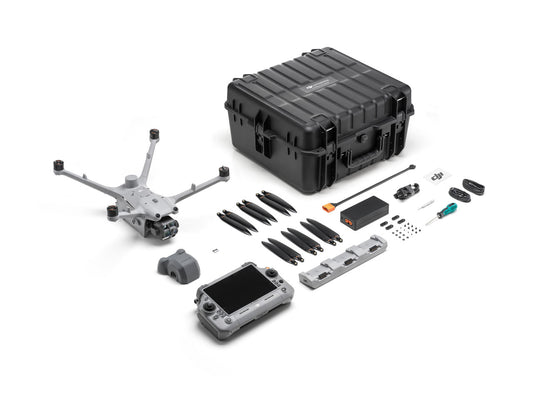
DJI Matrice 4T Deer Recovery Kit | 4 Batteries + Spotlight
Regular price $7,469.55 USDRegular priceUnit price per$9,075.00 USDSale price $7,469.55 USDSale -
DJI Matrice 4T Police & Emergency Responder Kit | 4 Batteries + Spotlight + Speaker
Regular price $7,759.54 USDRegular priceUnit price per$9,365.00 USDSale price $7,759.54 USDSale -
Matrice 4T Battery (compatible with Matrice 4E)
Regular price $238.89 USDRegular priceUnit price per$259.00 USDSale price $238.89 USDSale -
DJI Mavic 3M Multispectral Package
Regular price $5,379.00 USDRegular priceUnit price per$5,729.00 USDSale price $5,379.00 USDSale -
DJI Mavic 3TA (Advanced - M3TA)
Regular price $6,449.00 USDRegular priceUnit price per$6,599.00 USDSale price $6,449.00 USDSale -
Matrice 4E Ready to Survey Kit (Permanent Offline Terra Included)
Regular price $8,989.00 USDRegular priceUnit price per$10,349.00 USDSale price $8,989.00 USDSale -
Matrice 4TD Ready To Fly Kit
Regular price $8,999.00 USDRegular priceUnit price per$9,899.00 USDSale price $8,999.00 USDSale -
Matrice 4E - Ready to Fly Package
Regular price $5,189.00 USDRegular priceUnit price per$5,189.00 USDSale price $5,189.00 USD -
DISCOUNT: DJI Matrice 30T Ready To Fly Kit
Regular price $8,979.00 USDRegular priceUnit price per$10,999.00 USDSale price $8,979.00 USDSold out -
DJI Matrice M400 RTK - Ready to Fly Package
Regular price $11,998.99 USDRegular priceUnit price per$14,810.00 USDSale price $11,998.99 USDSale -
DJI Matrice M400 RTK + Zenmuse L3 Combo - Ready to Fly Kit
Regular price $26,749.00 USDRegular priceUnit price per$29,600.00 USDSale price $26,749.00 USDSale -
 Sale
SaleZenmuse L3
Regular price $15,499.00 USDRegular priceUnit price per$17,400.00 USDSale price $15,499.00 USDSale -
Hylio PHOTON Scout Drone
Regular price $14,295.00 USDRegular priceUnit price per -
Autel Robotics EVO MAX 4N - Ready To Fly Kit
Regular price $7,989.00 USDRegular priceUnit price per$12,599.00 USDSale price $7,989.00 USDSold out -
Autel EVO Max 4T V2 – Ready To Fly Kit
Regular price $5,789.00 USDRegular priceUnit price per$7,999.00 USDSale price $5,789.00 USDSale