Call or Text: +1 (208) 425-2990
Email: Sales@DroneSprayPro.com

How Multi-Drone Systems Share Real-Time Data
Drones working together can double field coverage while cutting costs. Here's how multi-drone systems achieve this:
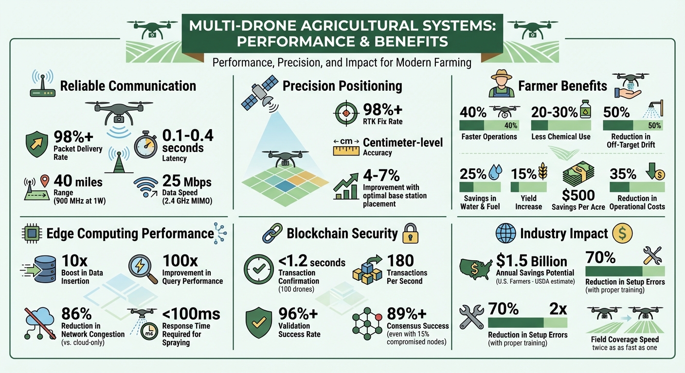
- Real-Time Communication: Drones share data like position, battery levels, and spray details using ISM band radios (900 MHz, 2.4 GHz) with a 98%+ packet delivery rate, even in tough conditions.
- Precision Positioning: RTK corrections ensure centimeter-level accuracy to avoid collisions and improve spraying efficiency.
- Smart Networking: Systems use 4G, Wi-Fi, or Local Network Terminals for stable connections, while edge computing reduces delays by processing data locally.
- Advanced Hardware: Tools like the PRIME board and RTK dongles enable fast, reliable data sharing with latencies as low as 0.1 seconds.
- Security: Blockchain ensures secure, tamper-proof data exchanges, even for large drone fleets.
Farmers using these systems experience up to 40% faster operations, 20-30% less chemical use, and $500 per acre savings. Multi-drone setups are transforming agriculture with precise, efficient, and synchronized operations.
Multi-Drone Systems: Key Performance Metrics and Benefits for Agriculture
How Drones Communicate During Operations
Communication Protocols and Networks
Agricultural drones depend on varied networking methods to ensure reliable communication, even across large farms with limited connectivity. One of the most common solutions involves ISM band radios, which operate at 900 MHz and 2.4 GHz frequencies. These radios use license-free spectrum bands, offering impressive capabilities: 900 MHz radios can achieve a 40-mile line-of-sight range at 1 watt, while 2.4 GHz MIMO modules provide faster data speeds of up to 25 Mbps [1].
In areas with cellular coverage, drones can leverage Duo Channel redundancy, combining 4G and Wi-Fi to maintain a stable connection. If one channel falters, the other takes over seamlessly. For fields without 4G coverage, a Local Network Terminal (LNT) acts as a portable Wi-Fi hub, enabling drones, controllers, and RTK stations to operate offline. This adaptability ensures smooth operations, regardless of infrastructure challenges.
Another critical component is ROS2 (Robot Operating System 2) middleware, which synchronizes real-time data from onboard systems like navigation sensors and computer vision cameras [1]. For shorter-range tasks, Bluetooth Low Energy (BLE) handles communication between drones and sensor tags within 33 feet. BLE uses channels CH37–CH39 to avoid interference with Wi-Fi, ensuring consistent performance [3].
These network protocols, paired with advanced hardware, enable the low-latency, reliable communication needed for effective drone operations.
Hardware for Data Transmission
The backbone of these communication systems lies in robust hardware that ensures real-time data transmission across multiple drones in the field. The PRIME board, for instance, integrates PICO 900 radios with Teensy 4.1 microcontrollers to transmit critical metrics like battery status and position data [1]. These radios achieve latencies as low as 0.1 to 0.4 seconds, allowing near-instant synchronization between drones [1].
Modern drones, such as the DJI Agras T50, come equipped with sensors to monitor factors like nozzle pressure, tank levels, and temperature. These sensors feed data back through the network, enabling drones to adjust spray parameters in real time. Notably, the T50 maintains RTK Fix rates above 98%, even in extreme temperatures ranging from -4°F to 122°F, thanks to a thermal management system that prevents overheating [4]. Additionally, careful placement of RTK base stations - avoiding heat-absorbing surfaces like dark pavement - can boost Fix rates by 4-7% [4].
Another key piece of hardware is the RTK dongle, which ensures centimeter-level accuracy for geotagging and precise field mapping. These dongles receive correction signals via ISM band radios, enabling highly accurate positioning. With a combination of reliable radio hardware and intelligent thermal design, drones can sustain dependable data transmission, even under challenging field conditions.
sbb-itb-3b7eef7
Robust Communication for Autonomous Drone Swarms
Data Processing and Synchronization Methods
Building on the advanced communication and hardware systems mentioned earlier, these methods aim to streamline data flow and improve decision-making for multi-drone operations.
Parallel Processing and Edge Computing
In large-scale operations, relying solely on cloud systems can lead to bottlenecks. Local data processing, or edge computing, steps in to tackle this issue by handling batches of image and sensor data on nearby ground-based servers. This approach significantly reduces delays and ensures operations continue smoothly, even with unreliable internet connections.
A standout example is AerialDB, developed by researchers at the University of Illinois Urbana-Champaign in August 2025. Tested with 400 drones and 80 edge devices, AerialDB demonstrated impressive results: a 10x boost in data insertion performance and a 100x improvement in query performance compared to traditional cloud systems. This was achieved using techniques like content-based hashing and Voronoi partitioning, which ensure drones connect to the closest edge server [5].
"AerialDB is able to scale efficiently while providing near real-time performance with different realistic workloads."
- Shashwat Jaiswal Suman Raj et al., University of Illinois Urbana-Champaign [5]
These advancements are critical for precision tasks. For instance, agricultural spraying operations demand response times under 100 milliseconds. At a typical flight speed of 20 feet per second, even a half-second delay could cause a drift of about 10 feet before adjustments are made. Edge computing helps avoid the approximate 1-second latency often encountered with LTE connections in remote farm areas [7]. While edge systems handle immediate, on-the-ground decisions, cloud platforms take care of larger-scale data management.
Cloud-Based Synchronization
Edge computing excels at handling real-time, local decisions, but cloud platforms shine when it comes to macro-level coordination. Acting as a central hub, the cloud aggregates data from multiple fields, processes historical datasets with deep learning models, and generates long-term forecasts, such as pest pressure trends or crop growth predictions. This allows farm managers to compare performance across different areas and seasons.
However, cloud synchronization can struggle with real-time demands. Limited rural bandwidth makes uploading large files like high-definition videos or LiDAR point clouds challenging, and connectivity issues can result in data gaps. Hybrid systems, which combine edge and cloud computing, alleviate these issues by reducing network congestion by 86% compared to cloud-only setups [6]. These systems reserve the cloud for intensive tasks - like climate simulations or training detection algorithms on massive datasets - while edge servers handle immediate analyses. This balance ensures both quick responsiveness and comprehensive data evaluation.
Data Security in Multi-Drone Operations
Operating drones in open fields introduces a range of risks: hacking, data interception, and identity verification issues. These challenges grow in dispersed operations, as agricultural drones rely on network transmissions for sensitive crop data, telemetry, and mission commands - making them vulnerable to interception [9]. Centralized systems exacerbate the problem by creating single points of failure; if the central hub is compromised, the entire fleet can be affected [8]. While encryption is essential to maintain telemetry integrity, it can also increase power consumption and slow down processing, which could disrupt time-critical tasks like spraying operations [9]. To tackle these challenges, blockchain technology provides a decentralized and secure alternative.
Blockchain-Based Security
Blockchain technology addresses these vulnerabilities by securing data exchanges with tamper-proof records. Instead of depending on a central server, blockchain operates through a distributed ledger where transactions are validated by multiple nodes. For instance, when a drone sends telemetry data or receives instructions, the system uses SHA-256 hashing to ensure data integrity. Any attempt to alter the data changes the hash value, breaking the chain and instantly signaling tampering [11][12].
"Blockchain technology can provide an efficient and scalable mechanism to advance smart farming and address some of the barriers that inhibit smart farming, particularly regarding to data integrity and availability."
- Kahlid Alqarni et al., Division of Informatics, Imaging & Data Sciences, University of Manchester [11]
Quantum-resilient blockchain systems further enhance security by confirming transactions in under 1.2 seconds for fleets of up to 100 drones. They can handle approximately 180 transactions per second while consuming less than 0.9 Joules per transaction. Validation success rates exceed 96%, and even in networks where 15% of drones are compromised, trust-based systems maintain a consensus success rate above 89% [10].
For farmers, this means every instruction sent to a spray drone can be verified, and sensor data integrity is guaranteed. Smart contracts automate processes like identity verification and access control, ensuring only authorized drones can issue commands or access sensitive data [9]. To optimize security for resource-constrained drone hardware, Elliptic Curve Cryptography (ECC) offers secure authentication with smaller key sizes compared to RSA [11]. Looking ahead, frameworks are integrating lattice-based cryptography, such as Dilithium-3 and Kyber-768, to protect drone networks from emerging quantum computing threats [10].
Benefits of Real-Time Data Sharing for Farmers
Improved Efficiency and Precision
Multi-drone systems that share real-time data bring noticeable improvements in both speed and accuracy. By coordinating flight paths and spraying patterns, these systems reduce chemical use by 20-30%, cut operation time by up to 40%, and generate real-time 3D field maps. These maps allow for precise variable-rate applications, which minimize off-target drift by 50% and increase yields by 15% [14][15][16][17]. For example, a corn farming case study showed a 15% increase in yields thanks to targeted interventions based on shared NDVI (Normalized Difference Vegetation Index) data [15][17]. In 2022 field trials, real-time synchronization boosted spraying accuracy to 95% in fleets of 10 drones [14].
Additionally, optimized routes save up to 25% in water and fuel by using shared GPS and sensor data [13][16]. These efficiencies translate into significant cost savings - field trials have reported up to $500 per acre saved and a 35% reduction in operational costs. Altogether, the USDA estimates these advancements could save U.S. farmers $1.5 billion annually [13][16]. These results highlight how advanced multi-drone coordination is transforming farming practices, offering tailored solutions for modern agricultural needs.
Drone Spray Pro's Multi-Drone Support
These advancements in efficiency and precision have opened the door for integrated solutions in farming, with Drone Spray Pro leading the charge. The company provides the tools and expertise necessary for multi-drone operations, offering pre-configured packages featuring top models like DJI Agras drones, Talos T60X, XAG, and ABZ Innovation. Each system is equipped for coordinated operations, with RTK mobile stations ensuring centimeter-level positioning accuracy for synchronized mapping and spraying.
Drone Spray Pro goes beyond just selling equipment. They also assist with FAA licensing and offer hands-on training specifically tailored to multi-drone swarm management. This training reduces setup errors by 70% for first-time users. Farmers using their systems report twice the field coverage speed, with one Idaho orchard cutting herbicide use by 30% through shared real-time canopy data [17]. Their packages are designed to meet the needs of U.S. farms, featuring high-capacity batteries and chargers to support extended operations. This ensures drones stay synchronized during critical spraying windows, allowing farmers to maximize efficiency and precision in their fields.
Conclusion: Multi-Drone Data Sharing in Modern Agriculture
Multi-drone systems are revolutionizing agriculture by enabling real-time data sharing through advanced wireless protocols, centralized management, and synchronized operations. These systems utilize dependable ISM band radios, achieving impressive performance with packet delivery ratios exceeding 98% and latencies as low as 0.1–0.4 seconds [1]. Tools like QGIS, DroneDeploy, and DJI Terra, paired with RTK-enabled positioning, provide centimeter-level accuracy [1]. Additionally, cloud-based platforms aggregate telemetry data, updating drone positions every 6 seconds and refreshing coverage maps every 30 seconds [18].
This technology directly enhances field operations. By assigning high-capacity drones to uniform zones and smaller, agile units to irregular areas, field coverage can effectively double [2]. As Drone Spray Pro highlights:
"Running both drones together means you don't have to choose between brands - you can harness the best of both worlds." - Drone Spray Pro [2]
Companies like Drone Spray Pro are pivotal in making these systems accessible to farmers across the U.S. They provide agricultural drones, assist with FAA licensing, and offer on-site training to ensure efficient operations, including proper zone assignments, staggered launches, and uniform nozzle settings.
With advancements in wireless communication and edge computing, multi-drone operations are becoming more accessible. Equipped with the right tools, training, and infrastructure, U.S. farmers are leveraging real-time data sharing to transform agricultural practices and improve productivity.
FAQs
What equipment do I need to run multiple drones on one farm?
To operate multiple drones on a farm, you’ll need the right mix of equipment and software. Start with agricultural drones that are built to work together seamlessly. Pair them with mission planning software to map out flight paths and communication tools to keep everything in sync.
Key components include RTK modules for pinpoint positioning and cloud-based platforms to sync and store your data. Reliable controllers, along with compatible batteries, chargers, and sensors, are also critical for smooth operations. These tools work together to enable real-time data sharing and ensure your drones can coordinate effectively, covering your farm efficiently.
How do drones avoid collisions when flying and spraying together?
Drones steer clear of collisions during joint operations by relying on advanced trajectory planning algorithms and real-time data sharing. Tools like MADER and Robust MADER play a key role here, enabling drones to craft collision-free flight paths. Even when communication delays occur, these systems allow drones to share and adjust their routes dynamically, ensuring smooth coordination.
On top of that, drones are equipped with sensors such as LiDAR and multispectral cameras, paired with AI-powered processing. These technologies help drones analyze their surroundings, navigate obstacles, and execute tasks like precise spraying - all while maintaining safety in shared airspace.
Will a multi-drone system still work if my fields have no cell service?
Yes, multi-drone systems can function without cell service when they use RTK technology paired with a local base station or similar correction methods. On the other hand, setups that depend on cloud-based systems or network connections typically require cell service for sharing real-time data.