Call or Text: +1 (208) 425-2990
Email: Sales@DroneSprayPro.com

RTK Signal Accuracy: Common Issues and Fixes
- RTK Basics: A base station provides real-time GPS corrections, enabling drones to achieve 1–2 cm accuracy. This precision prevents wasted chemicals, overlaps, and missed areas during spraying or mapping.
-
Common Problems:
- Distance from Base Station: Accuracy drops beyond 30 km; over 50 km, it's unreliable.
- Satellite Positioning: Poor geometry or high PDOP values (above 4.0) reduce precision.
- Obstructions: Trees, buildings, and metal surfaces cause signal interference.
- NTRIP Issues: Weak internet connections or outdated corrections disrupt RTK FIX status.
- Float Mode: Without a FIX, accuracy falls to 10–30 cm, affecting results.
-
Solutions:
- Stay within 20–30 km of the base station and ensure an open sky view.
- Monitor PDOP and wait for better satellite conditions if needed.
- Avoid reflective surfaces and set up in obstruction-free areas.
- Use stable internet (ping under 20 ms) and reliable NTRIP settings.
- Always wait for "RTK FIX" before starting operations.
Key Tip: After battery swaps, allow 60–90 seconds for the RTK module to regain FIX status. This ensures consistent precision throughout your mission.
Proper setup, regular maintenance, and reliable hardware like RTK dongles, base stations, or advanced sprayer drones like the DJI Agras T50 can help maintain accuracy, saving time and resources in the field.
How Accurate is RTK with Your Drone?
sbb-itb-3b7eef7
Common RTK Signal Problems
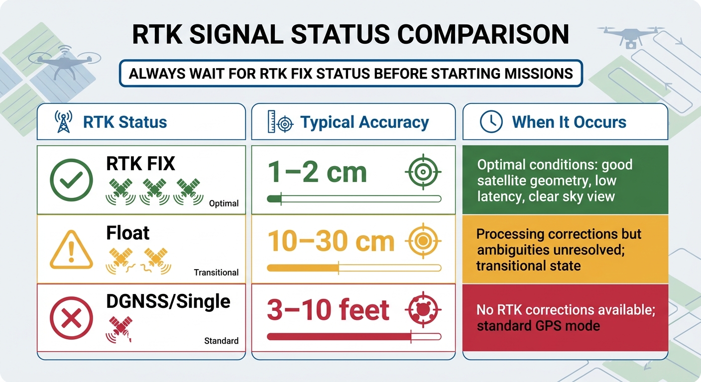
RTK Status Comparison: Accuracy Levels and Optimal Conditions
RTK technology offers centimeter-level precision, but achieving that accuracy in the field can be a challenge. Several factors can interfere with RTK performance, and understanding these issues is key to troubleshooting and avoiding errors during tasks like spraying or mapping.
Excessive Distance from Base Station
The distance between your drone and the base station is one of the biggest factors affecting RTK accuracy [3]. When you're within 30 km of a base station, you can typically achieve centimeter-level accuracy (around 2 cm). However, as the distance grows, accuracy begins to drop. Between 30–50 km, atmospheric interference becomes more noticeable, and it takes longer to achieve a FIX. Beyond 50 km, maintaining a stable RTK FIX becomes nearly impossible, and the system may stay in "Float" mode, with accuracy dropping to 10–30 cm or worse [3]. Additionally, base station errors increase with distance, introducing about one part per million (1 ppm) error for every kilometer [5].
Signs that you're too far from the base station include messages like "RTK Signal Weak", "No RTK Data Available", or a status indicator stuck on "Converging" for more than 2 minutes without reaching "FIX." Alongside distance, satellite positioning plays a crucial role in RTK precision.
Poor Satellite Positioning and High DOP Values
The way satellites are positioned in the sky can impact accuracy as much as the number of satellites available. If satellites are clustered together instead of evenly spread out, it can lead to high PDOP (Position Dilution of Precision) values, which reduce positioning quality.
For reliable accuracy, aim for a PDOP value of 4.0 or less. Values between 4.0 and 7.0 indicate degraded conditions, while anything above 7.0 significantly affects RTK performance [5]. Ideally, you should have at least 10 well-distributed satellites for consistent results.
Multipath Interference from Obstacles
Physical barriers can be a major headache for RTK accuracy. When GNSS signals bounce off surfaces like buildings, trees, or metal structures before reaching the drone's antenna, the receiver may get confused by these reflected signals. According to RTKdata.com, "Multipath interference (signals bouncing off buildings or metal) is the #1 accuracy killer after distance" [4].
In agricultural environments, obstacles like grain bins, dense tree canopies, or large metal sheds often cause this issue. To minimize interference, ensure your DJI D-RTK 2 Mobile Station and takeoff point have an unobstructed view of the sky, with no obstacles above a 15-degree elevation [4].
NTRIP Connection Failures and Outdated Corrections
RTK accuracy depends on receiving correction data in real time, so any disruption to your internet connection can cause problems. When using NTRIP (Networked Transport of RTCM via Internet Protocol) for corrections, unstable connections or high latency can knock your drone out of "FIX" mode and into "FLOAT" mode mid-flight.
Here’s what to aim for:
- Latency: Less than 1 second is ideal; 1–3 seconds is manageable, but anything over 3 seconds is problematic [4][6].
- Correction age: Should be no older than 1 second [6].
- Internet ping: Under 20 ms is good; 20–50 ms is borderline; over 50 ms is poor [6].
Weak Wi-Fi or using a VPN can add latency, further affecting performance. For DJI Agras T40 users, ensuring a secure hardware connection via a dedicated RTK dongle connector can help maintain signal stability.
Float Solutions vs. RTK Fix Status
Knowing the difference between "Float" and "RTK FIX" is critical for achieving precise results. In "Float" mode, the drone processes corrections but hasn't resolved carrier phase ambiguities, leaving accuracy at 10–30 cm. On the other hand, "RTK FIX" provides 1–2 cm accuracy [3].
Always wait for a "FIX" status before starting a mission [3]. Launching in "Float" or "Converging" mode can lead to poor accuracy throughout the operation. After swapping batteries, the RTK module resets, requiring the drone to stay stationary to re-establish a FIX. This process usually takes 60–90 seconds under a clear sky [3][4].
| RTK Status | Typical Accuracy | When It Occurs |
|---|---|---|
| RTK FIX | 1–2 cm | Optimal conditions: good satellite geometry, low latency, clear sky view |
| Float | 10–30 cm | Processing corrections but ambiguities unresolved; transitional state |
| DGNSS/Single | 3–10 feet | No RTK corrections available; standard GPS mode |
Solutions for RTK Signal Problems
Here’s how to tackle RTK issues with practical solutions.
Base Station Setup and Distance Management
To maintain a stable RTK fix, keep your drone within 20–30 km of the base station[6]. Beyond this range, you might face longer convergence times and more frequent drops into float mode. For missions requiring greater range, consider setting up a local base station.
Place the base station antenna in a high, open area with a clear view of the sky. Avoid locations near metal structures or dense foliage. Also, double-check the baseline distance in your flight app to ensure everything is configured correctly[4].
Checking Satellite Geometry and DOP Levels
Ensure your PDOP (Position Dilution of Precision) is below 4.0 and that at least 10 satellites are locked[3]. If satellite geometry is poor at certain times, use a GNSS planning tool to identify better times for operation. Sometimes, simply waiting for improved conditions can significantly shorten convergence times.
Minimizing Multipath Interference
Even a small adjustment - like moving 20 meters away from a building - can greatly enhance signal quality[4]. Before takeoff, scan the area for reflective surfaces such as metal, water tanks, or dense tree lines. If you spot any, relocate to an open field with no obstructions above a 15-degree elevation from the horizon.
For permanent base stations, choose a location free from obstructions. For instance, a base station placed near a metal shed may deliver inconsistent performance depending on satellite positions. Taking the time to carefully select the placement can ensure smoother RTK operations.
Maintaining Reliable NTRIP Connections
A stable internet connection is crucial. Test your connection using tools like Speedtest - pings under 20 ms are ideal, while anything over 50 ms could cause issues[6]. Disable any VPNs on your devices to reduce latency[4].
For connectivity, built-in 4G controllers are reliable. Other options include USB 4G dongles or phone hotspots, which should be kept near the controller. In remote areas with no cellular service, satellite internet providers like Starlink can be a dependable alternative. Carrying a backup SIM card from a different carrier is a smart precaution in areas with spotty rural coverage.
In your NTRIP settings, make sure "Send GGA to Caster" is enabled. This ensures the network receives your location and provides the nearest corrections. Set your mountpoint to "AUTO" (all caps) and use Port 2101 for standard connections[3]. Additionally, keep an eye on the correction data age in the RTK status screen - it should stay under 1 second for the best results[6].
Getting and Keeping RTK Fix
Always wait until "RTK FIX" appears in your flight app before launching[3]. Power up your drone in the takeoff area and keep it stationary on the ground while the RTK module converges, which usually takes 60–90 seconds. Rushing this step can compromise accuracy throughout your mission.
After swapping batteries, allow the RTK module another 60–90 seconds to reconverge[3]. Set the drone down, wait for the fix status to return, and then resume your flight. This short wait ensures centimeter-level precision. Many operators use this downtime to inspect the drone or check spray nozzles, making the most of the pause.
Lastly, keep your drone firmware up to date and perform a compass calibration when operating in a new area or if you notice drifting during hover. Regular maintenance, like cleaning antenna connections and inspecting cables, can help prevent unexpected problems during your missions.
RTK Accessories and Hardware Upgrades
Enhancing your hardware can go a long way in addressing RTK signal challenges encountered in the field. These upgrades are tailored to tackle issues like NTRIP connection interruptions and inaccuracies caused by distance, complementing the software solutions discussed earlier.
Using RTK Dongles for Better Connectivity
An RTK dongle can transform a standard remote controller into a high-precision RTK receiver without needing a physical base station[7]. These lightweight devices - typically under 100 grams - connect directly to controllers like the DJI RC Plus and deliver centimeter-level accuracy, achieving precision down to ±10 cm both horizontally and vertically[7]. This makes them particularly effective for tasks like precise mapping and mission planning.
The DJI Agras RTK Dongle is an excellent example. It provides a dedicated internet connection for NTRIP correction data, ensuring the RTK system maintains a "Fix" status in the field[8]. Setting up a dongle is much quicker compared to deploying a physical base station, and the correction data required is minimal in size[2].
When using a dongle, be sure to disable the "D-RTK 2 Search" toggle in your DJI Agras app to avoid connection conflicts[8]. Before taking off, confirm that your controller displays a green "FIX" status. Yellow "FLOAT" or red "SINGLE" indicators signal reduced accuracy, which could result in overlapping or missed spray strips[8]. For rural areas with weak cellular coverage, pairing the dongle with a high-gain 4G antenna can help maintain a steady connection to the NTRIP caster[8].
If dongles don’t fully address your needs, other hardware solutions can further enhance RTK performance.
Other Hardware for RTK Performance
When cellular service is unreliable, additional hardware can ensure consistent RTK functionality. For remote locations, Starlink satellite internet offers the low-latency connectivity required for stable RTK corrections[2]. Alternatively, a dedicated MiFi device or mobile hotspot can act as a reliable backup to maintain your data link.
Physical base stations, like the DJI D-RTK 2, are another dependable option. These stations are particularly effective when positioned in open, elevated areas. It’s crucial to use the same RTK source or NTRIP network for both mapping and spraying drones to avoid discrepancies between planned flight paths and actual spray coverage[1].
Conclusion
Managing RTK signal challenges is key to ensuring precision in agricultural drone operations. Issues like long distances from base stations, poor satellite geometry, multipath interference, NTRIP connection problems, and unstable fix statuses can all be tackled with the right knowledge and preparation.
For optimal accuracy, always confirm a stable "RTK FIX" status and allow for brief stationary periods (60–90 seconds) after battery changes. A low-latency connection - ideally with a ping under 20 ms - is crucial for real-time corrections. As highlighted in Pix4D’s documentation:
Please ensure you use the same GPS RTK NTRIP network for the mapping drone and the spraying drone, sprayer, or tractor. Otherwise, large location errors are possible. [1]
This consistency is essential to avoid coordinate shifts that could result in missed spray areas or even collisions between equipment.
Beyond these measures, quality accessories can further enhance RTK performance. Tools like USB 4G dongles and RTK dongles, such as the DJI Agras RTK Dongle, provide reliable NTRIP connections without requiring a physical base station. These devices integrate seamlessly into your RTK setup, maintaining accuracy throughout your operations.
Long-term precision depends on proactive RTK maintenance. Keeping a stable "Fixed" status ensures horizontal accuracy within 1–2 cm, compared to the much less precise 30–100 cm in "Float" mode. This level of precision ensures your mapping data matches your application coordinates perfectly, allowing for targeted input application and improved crop management season after season.
For farmers in Idaho and beyond, Drone Spray Pro offers top-tier accessories and expert guidance to ensure your drones operate with unmatched accuracy in diverse farming conditions.
FAQs
How do I choose between a base station and NTRIP for RTK?
The choice between a base station and NTRIP largely depends on your specific environment and the availability of connectivity.
A base station is ideal for situations where you need high accuracy and stability, particularly in remote locations where cellular signals are weak or nonexistent. Since it operates independently of the internet, it’s a reliable option for precision work in isolated areas.
On the other hand, NTRIP (Networked Transport of RTCM via Internet Protocol) relies on internet-based correction data, making it a more flexible solution for covering larger areas. However, it does require a stable and reliable internet connection to function effectively.
In essence, if precision and independence are your priorities, go with a base station. But if convenience and coverage in well-connected areas matter more, NTRIP is the better choice.
Why does my drone lose RTK FIX during a flight?
When a drone loses its RTK FIX, it’s often due to weak signal quality or external factors. A few typical culprits include being more than 30 km away from the base station, having an obstructed view of the sky (think tall buildings or dense trees), or dealing with a poor network connection. Other issues, like thick vegetation, outdated firmware, or loose cables, can also disrupt performance.
To keep things running smoothly, make sure the sky view is clear, regularly check and maintain your equipment, and place base stations in open, unobstructed areas.
What’s the fastest way to regain RTK FIX after a battery swap?
To get RTK FIX back quickly after a battery swap, make sure the drone is powered on in an open area with a clear view of the sky. Allow time for the satellite lock, and ensure the drone is within 30 km of the base station. Having a strong internet connection and a solid satellite signal (at least 10 satellites) can make the process faster. Reconnecting might take up to 3 minutes.