Call or Text: +1 (208) 425-2990
Email: Sales@DroneSprayPro.com

Integrating OGC Standards with Drones
OGC standards are transforming how drones are used in agriculture by ensuring compatibility across mapping tools, farm management software, and drone systems. These standards streamline the integration of geospatial data, making it easier for farmers to use drone-collected insights for tasks like precision spraying, field mapping, and crop monitoring. Here's what you need to know:
- Why it matters: Without OGC standards, drone data often gets stuck in incompatible formats or isolated systems, making it hard to use effectively.
- Key technologies: Standards like GeoJSON, LAS, and APIs such as OGC API – Features simplify data sharing, reduce errors, and enable real-time updates.
- Challenges: Farmers face hurdles like outdated drone systems, mismatched coordinate systems, and siloed data, which slow down adoption.
- Solutions: Tools like GDAL for data conversion, middleware for integration, and compliance testing ensure smooth workflows and accurate results.
OGC standards are helping farmers reduce chemical use by up to 30% and increase crop yields through precise, data-driven decisions. These protocols are shaping the future of agricultural drones by breaking down technical barriers and improving efficiency.
Common Problems When Integrating OGC Standards with Agricultural Drones
Incompatible Geospatial Data Formats
One of the biggest hurdles in integrating OGC standards with agricultural drones is the mismatch between older XML-based OGC Web Services and newer JSON-based OGC APIs. Many drones used in agriculture still rely on outdated standards, making it tough to connect with modern farm management software [1]. Even when systems claim compatibility with the same API, differences in data formats - such as GeoJSON, GeoPackage, or GeoTIFF - can lead to processing errors [5].
Another challenge arises with Coordinate Reference System (CRS) mismatches. While OGC standards default to WGS 84, some drones generate data in other coordinate systems without including proper metadata. This causes spatial misalignments that complicate data integration across platforms [5]. Addressing these format and CRS inconsistencies is essential for smooth interoperability, as they often lead to broader issues like isolated datasets.
Data Silos in Precision Agriculture
Proprietary software tools used for mission planning and image processing often trap valuable data in silos. Many UAV manufacturers prioritize their own ecosystems, limiting interoperability [6]. For example, a single drone operation can generate 2–4 GB of flight data, which is then locked into proprietary formats. Uploading this data can also be painfully slow - just 1 GB might take 25 minutes on a 10 Mbps connection - making integrated crop analysis a logistical nightmare [6].
This fragmentation is further complicated by the divide between local processing tools like Pix4D or Agisoft and cloud-based platforms like DroneDeploy. Without standardized exchange formats, combining datasets from different sensors or platforms for comprehensive crop analysis becomes nearly impossible [6]. Breaking down these silos is key to creating the unified data systems that OGC standards aim to support.
Regulatory and Operational Barriers
In addition to technical challenges, regulatory and operational issues make integration even harder. The shift from legacy XML-based systems to modern resource-centric APIs requires advanced technical skills. For many farmers and agricultural service providers, this transition is daunting because they lack the in-house expertise needed to adapt to these modern web practices. This gap makes it difficult to integrate data seamlessly into precision agriculture workflows, further complicating the adoption of OGC standards.
OGC Standards for Agricultural Drones
Core Standards: WMS, WFS, and GeoJSON
Web Map Service (WMS) makes it easy to share drone-captured maps across different platforms without compatibility headaches. For example, if your spray drone captures field imagery, WMS ensures you can view those maps in any software that supports the standard - whether that's your farm management system or a third-party analytics tool [8].
Web Feature Service (WFS) is designed for vector data like field boundaries, crop rows, or GPS points identified by your drone. This standard allows you to share and edit these features seamlessly across various systems [8]. Then there’s GeoJSON, which has become the go-to format for modern web applications. As OGC describes it:
"a lightweight data model and encoding standard used to represent simple geographical features and their non-spatial attributes"
[7]. GeoJSON is particularly handy for sharing drone data through APIs, thanks to its simplicity and compatibility with web technologies.
The introduction of OGC API - Features marks a big step forward from the older WFS standard. This modern API, now an international standard under ISO 19168-1:2020 [11], is designed with today’s web practices in mind. Forget about wrestling with complex XML requests - this API lets you access specific field data using straightforward HTTP methods. It’s a much cleaner way to integrate drone data into precision agriculture workflows.
These core standards lay the groundwork for handling drone data, while specialized formats take things further for advanced sensors.
Specialized Formats: LAS and 3D Tiles
If your drone is equipped with LiDAR sensors, the LAS specification becomes crucial. This format is the industry standard for point cloud data, enabling the creation of highly detailed 3D models of terrain and crop height [7][9]. These models help fine-tune spray patterns and better understand variations in crop health.
3D Tiles, on the other hand, is perfect for streaming large, complex 3D datasets. OGC explains:
"3D Tiles is an open standard for streaming massive heterogeneous 3D geospatial datasets"
[10]. This format supports two key refinement strategies: "REPLACE" swaps out lower-resolution imagery for higher-resolution data, while "ADD" incrementally adds detail as you zoom into specific areas [10]. These capabilities make it easier to manage and analyze drone data, even at a large scale.
Together, these specialized formats pave the way for real-time, dynamic data integration through API extensions.
API Extensions for Real-Time Integration
OGC API extensions bring real-time data exchange to the table, allowing drones and farm management systems to communicate seamlessly. Instead of downloading entire datasets, OGC API - Features gives you fine-grained control, letting you update specific field attributes - like tagging a new pest zone - without dealing with massive files [11].
For raster data from multispectral or thermal sensors, OGC API - Coverages is the go-to option. It lets you request specific spatial areas using bbox parameters or focus on particular spectral bands using properties, all without the need to download huge files [12]. Meanwhile, OGC API - Tiles is key for real-time drone tracking and efficient streaming of map layers. These modular APIs allow you to pick and choose the components that best fit your operation’s needs [11][12].
How to Integrate OGC Standards with Agricultural Drones
Step 1: Ensure Drone Hardware and Software Compatibility
First, confirm that your drone's hardware and software can handle the necessary OGC formats. Match the data type to the appropriate format: OGC GeoTIFF or Cloud Optimized GeoTIFF for imagery, LAS for 3D point clouds from LiDAR sensors, and GeoJSON for vector data like field boundaries [1]. If you’re working with a mixed fleet from various manufacturers, tools like DroneLogbook – Agriculture Edition can simplify things. This software supports over 80 telemetry file types and allows API integration to sync drone data with farm management systems [13].
For drones like DJI Agras models, ensure that RTK dongles and onboard sensors can output data compatible with modern OGC APIs. Once compatibility is confirmed, convert raw data into the required standard formats.
Step 2: Convert Drone Data to OGC-Compliant Formats
Next, transform your drone's raw data into OGC-compliant formats. Tools like GDAL are ideal for converting data into formats such as GeoJSON, WMS layers, or Cloud Optimized GeoTIFF [1]. The OGC Schema Repository provides detailed specifications to structure your data correctly, ensuring that field boundaries, spray zones, and sensor readings are properly labeled for seamless integration [1].
For multispectral imagery, use GeoTIFF for mapping, while 3D field models should be saved in LAS format [1]. Automating this process can save time. For instance, platforms that integrate with DJI Agriculture drones can not only generate FAA Part 137 compliance reports but also automate the conversion of telemetry data into standardized formats [13].
Step 3: Deploy Middleware for System Integration
Once your data is standardized, use middleware to connect your systems smoothly. Middleware bridges the gap between drone data and farm management systems using OGC APIs for real-time synchronization. For example, OGC API – Features enables you to update specific field attributes, like marking a pest-infested area, without needing to download entire datasets [1]. This targeted approach is far more efficient than older methods.
Choose middleware that supports multiple data types. OGC API – Tiles is great for real-time drone tracking and map streaming, while SensorThings API integrates drone-mounted sensors with other IoT devices on your farm [1]. The ultimate goal is to create a seamless flow of information between your drone's telemetry, multispectral sensors, and your farm management software.
Step 4: Test and Validate System Interoperability
Testing is a critical step to avoid issues during field operations. Use the OGC Compliance Testing (CITE) program to validate that your systems conform to OGC standards [5]. Instead of testing an entire standard at once, focus on specific "Conformance Classes", such as requirements for "Collections", "JSON", or "HTML" [5].
"The framework, concepts, and methodology for testing, and the criteria to claim conformance are specified in the OGC Compliance Testing Policies and Procedures and the OGC Compliance Testing web site" [5].
Leverage OpenAPI 3.0 definitions to create machine-readable documentation that checks your drone data outputs against official OGC schemas [5]. Always verify responses against components in the OGC schema repository to ensure your data is structured correctly. For spatial data, remember to use the default coordinate reference system, OGC:CRS84 (WGS 84 longitude and latitude), and format timestamps according to RFC 3339 [5]. This thorough validation process will save you from compatibility issues when sharing data across platforms.
sbb-itb-3b7eef7
Benefits of OGC Standards in Precision Agriculture
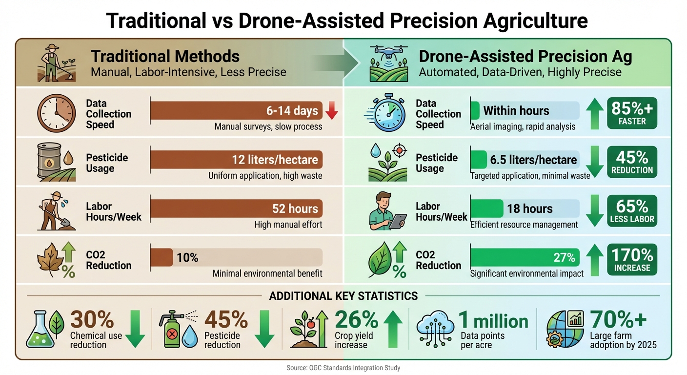
Traditional vs Drone-Assisted Precision Agriculture: Key Performance Metrics
Improved Workflows for Precision Spraying
OGC standards are reshaping how agricultural drones handle precision spraying, making the process smarter and more efficient. Through the OGC SensorThings API, drones gain access to a standardized framework for IoT sensor data in a spatial context. This allows drones to identify exactly where crops need attention, cutting down on guesswork and reducing waste [15]. When drones communicate seamlessly with ground sensors and farm management systems, chemical use decreases significantly.
For example, precision spraying with drones has been shown to reduce chemical use by 30% and pesticides by over 45%. By 2025, it's estimated that more than 70% of large farms will adopt this technology [3][16].
| Aspect | Traditional Methods | Drone-Assisted Precision Ag |
|---|---|---|
| Data Collection Speed | 6–14 days | Within hours |
| Pesticide Usage | 12 liters/hectare | 6.5 liters/hectare |
| Labor Hours/Week | 52 hours | 18 hours |
| Sustainability (CO2 Reduction) | 10% | 27% |
These advancements not only streamline workflows but also set the stage for integrating more sophisticated data approaches.
Better Data Sharing and Reusability
Beyond improving operations, OGC standards enhance how agricultural data is shared and reused. Formats like LAS for 3D point clouds and GeoTIFF for geographic imagery eliminate the need for manual data conversions, making it easier to integrate drone data across various software platforms [1]. This is critical given that drones can generate up to 1 million data points per acre [16].
Standards such as the SpatioTemporal Asset Catalog (STAC) and OGC API – Records simplify the retrieval of geospatial resources, like historical crop health maps from previous seasons [1]. By building a reusable library of field data, farmers can make better decisions over time. Targeted inputs and stress management, powered by these practices, can result in a 26% increase in crop yields [16].
Security and Data Integrity in Agricultural Applications
With so much data being shared, ensuring its security is crucial. The GeoXACML standard provides detailed access control for geospatial data, allowing only authorized users to view sensitive maps and field information [7]. Meanwhile, the Web Services Security standard ensures secure and reliable data exchange between drones and farm management systems [7].
OGC standards also align with the FAIR principles (Findable, Accessible, Interoperable, and Reusable), ensuring agricultural data remains trustworthy and useful over the long term. This reliability supports better decision-making and compliance with regulations [4]. Opting for OGC-compliant hardware further ensures compatibility and future-proofing [14].
How Drone Spray Pro Supports OGC Integration
Pre-Made Drone Packages for OGC Compliance
Drone Spray Pro offers Ready to Fly packages designed for seamless OGC integration, featuring high-precision technology that’s ready to deploy. Among the standout options, the DJI Matrice 400 RTK ($10,998.99) and DJI Mavic 3M Multispectral ($5,529.00) packages come equipped with RTK technology, ensuring centimeter-level positioning accuracy. This precision is crucial for creating OGC-compliant geospatial data formats like GeoJSON and WMS [17].
For data capture, the Zenmuse L3 LiDAR sensor ($15,789.00) produces LAS-compatible point clouds, while the Mavic 3M’s multispectral imaging supports 3D Tiles [17]. For large-scale spraying tasks, the DJI Agras T100 – Fly All Day ($39,999.00) and Talos T60X ($28,194.00) combine RTK precision with the ability to cover 40–60 acres per hour [17]. Each package includes the necessary batteries, chargers, and controllers, ensuring operators can deploy their drones immediately [18].
These all-in-one hardware solutions ensure operators are equipped to meet regulatory and operational standards with ease.
Training and FAA Licensing Assistance
Drone Spray Pro goes beyond hardware by offering support for critical certifications. They assist operators in obtaining FAA Part 107 licenses, state-specific agricultural spray certifications, Section 44807 exemptions for drones exceeding 55 pounds, and FAA Medical Certificates [17][20]. The company’s Ag Drone Resources library provides step-by-step guides on FAA certification processes and strategies for scaling multi-drone operations to maintain OGC compliance.
For those in Southeast Idaho, Drone Spray Pro offers free equipment demonstrations. These demos showcase real-world data collection using advanced sensors like thermal, multispectral, and LiDAR, helping operators see the technology in action [17].
This comprehensive support ensures operators can focus on efficiency and compliance without unnecessary hurdles.
Improving Precision and Productivity with Drone Spray Pro
Drone Spray Pro’s RTK-enabled packages allow operators to start collecting highly accurate data immediately, meeting OGC standards like WFS and GeoJSON [17][19]. Both the DJI Mavic 3M and Matrice 4T packages deliver the raw spectral data necessary for detailed, OGC-compliant analysis across various platforms [17].
"Our spray drone packages include everything you need to get operational fast. Farmers use them to save. Hustlers use them to earn. You can do both." – Drone Spray Pro [17]
These solutions empower agricultural professionals to effortlessly comply with OGC standards while optimizing field data integration and productivity.
Conclusion: OGC-Enabled Drones in Agriculture
Bringing OGC standards into the world of agricultural drones is transforming how geospatial data is gathered and applied. These standardized protocols break down compatibility issues between drones, sensors, and farm management tools, creating a smooth process from capturing data to applying it with precision [1]. Using formats like GeoJSON and LAS, drones can communicate directly, enabling real-time, accurate decision-making in the field.
Modern OGC APIs take this integration even further by simplifying data exchange. With web-based standards like OGC API – Features and OGC API – Tiles, farmers can process drone data more efficiently, leaving behind clunky, outdated XML systems [1]. This level of interoperability allows a multispectral map created on one platform to seamlessly produce prescription files for automated sprayers - no manual conversions needed.
"When farmers can perform precision spraying based on accurate data, their crop yields and production can go up while waste declines." – DJI Enterprise [2]
The advantages go well beyond just making systems work together. With RTK-enabled drones, farmers gain centimeter-level accuracy, ensuring that prescription maps perfectly match field conditions. This not only reduces chemical usage but also helps meet regulatory requirements [2]. Plus, drones deliver fresher, high-resolution imagery, giving farmers the most up-to-date insights for their operations.
FAQs
How do OGC standards help agricultural drones work better with other systems?
OGC standards lay the groundwork for seamless sharing and management of geospatial data. By offering standardized data models, APIs, and metadata specifications, they make it easier for tools like agricultural drones, farm-management systems, and data processing platforms to work together without a hitch.
This level of interoperability streamlines workflows, boosts data accuracy, and supports better decision-making for farmers relying on drones for tasks such as crop monitoring or spraying. Embracing these standards ensures devices and platforms communicate effectively, ultimately making precision agriculture more efficient and dependable.
What challenges arise when integrating OGC standards with agricultural drones?
Integrating Open Geospatial Consortium (OGC) standards with agricultural drones isn't exactly a walk in the park. One of the biggest hurdles lies in the differences between communication protocols and data formats. Many drones operate on proprietary systems, which makes creating a unified platform for seamless data sharing and processing quite tricky. To tackle this, operators often have to align protocols like DDS or MQTT and ensure data is consistently encoded in formats such as JSON or XML.
Another major challenge is handling the sheer volume of geospatial data that drones produce - think multispectral imagery and LiDAR data. Without a strong cloud infrastructure and standardized APIs, storing, visualizing, and analyzing this data while staying compliant with OGC standards becomes a daunting task. On top of that, integrating older firmware or third-party accessories with OGC-defined services often demands extensive testing and updates, which can quickly drive up both time and costs.
And let’s not forget about FAA regulations. Compliance with rules around UAS detection and safety adds yet another layer of complexity. Any OGC-enabled solution must not only meet technical requirements but also align with aviation safety standards, making the integration process even more intricate.
How can farmers ensure their drones work seamlessly with OGC standards?
To make sure your agricultural drones align with Open Geospatial Consortium (OGC) standards, think of them as geospatial data sources. Connect them to APIs and services commonly used in GIS systems. Choose flight-planning and data-capture tools that are compatible with modern OGC APIs, such as:
- OGC API-Features for handling vector data
- OGC API-Maps for working with imagery
- OGC API-Processes for real-time analytics like NDVI or spray-rate calculations
Use the SpatioTemporal Asset Catalog (STAC) specification to organize drone-generated data. This approach helps you manage metadata - like timestamps, coordinates, and payload details - efficiently while ensuring the data works seamlessly with OGC-compliant systems. For added functionality, consider integrating tools like the Coordinate Transformation Service to convert GPS coordinates into local systems, or the OGC SensorThings API for streaming real-time sensor data.
Drone Spray Pro provides specialized solutions, including firmware configurations, RTK modules, and training, to help farmers establish OGC-compliant workflows, ensuring their drones work smoothly with GIS tools.