Call or Text: +1 (208) 425-2990
Email: Sales@DroneSprayPro.com

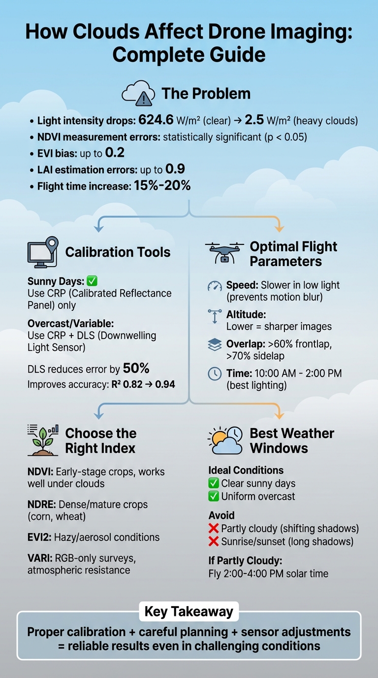
How Clouds Affect Drone Imaging
Clouds can disrupt drone imaging in several ways, impacting light, sensor accuracy, and data quality. Reduced light intensity, uneven illumination, and changes in light wavelengths can lead to noisy images, motion blur, and unreliable vegetation indices like NDVI. These issues are particularly challenging during partly cloudy conditions, where shifting shadows cause inconsistencies in data.
To mitigate these problems:
- Use Calibrated Reflectance Panels (CRP) and Downwelling Light Sensors (DLS) for better lighting calibration.
- Adjust flight settings: slower speeds, higher image overlap, and lower altitudes improve image quality.
- Choose the right vegetation index: NDVI works well under clouds, while NDRE is better for dense crops.
- Time flights between 10:00 AM and 2:00 PM for consistent lighting.
Cloudy weather may extend flight times by 15%-20%, but proper calibration, careful planning, and sensor adjustments can help maintain reliable results, even under challenging conditions.
Best Practices for Drone Imaging in Cloudy Weather Conditions
How Clouds Affect Drone Sensors and Image Quality
Clouds can significantly affect how light interacts with drone sensors, leading to changes in light intensity and wavelength that disrupt accurate crop health measurements.
Light Intensity Changes and Inconsistency
Partly cloudy conditions are particularly troublesome for drone surveys. As AgEagle/MicaSense explains:
The most difficult lighting conditions to work with are partially cloudy days with sharp transitions from shadow to sun. These kinds of conditions will most likely produce anomalies in the multispectral data [3].
When cumulus clouds move across the sky, they cast shifting shadows that create inconsistencies in the data - variations that have nothing to do with actual crop health [7]. This variability can increase the standard deviation of vegetation measurements, making it nearly impossible to separate true crop differences from lighting artifacts [4].
The intensity of direct sunlight can also swing dramatically, dropping from 624.6 W/m² under clear skies to as low as 2.5 W/m² during heavy cloud cover. These fluctuations can happen in under a second [5][6]. As a result, drone images often show uneven exposure across a single field, even when captured during the same flight.
Interestingly, fully overcast days are less problematic compared to partly cloudy ones. While overcast skies provide consistent lighting, the lower brightness reduces the sensor's signal-to-noise ratio. To address this, careful calibration using a Calibrated Reflectance Panel (CRP) and a Downwelling Light Sensor (DLS) becomes essential [3].
Beyond intensity, cloud cover also changes the spectral composition of light, further complicating multispectral data interpretation.
Changes in Light Wavelength Distribution
Clouds don't just affect how bright the light is - they also alter its wavelength distribution. Clouds scatter visible and near-infrared (VNIR) radiation while absorbing shortwave infrared (SWIR), causing a shift toward shorter wavelengths. This phenomenon, known as a "spectral slope", can significantly impact sensor readings [5].
For multispectral cameras, this creates challenges because different bands are affected unevenly. Ratios like NDVI (Normalized Difference Vegetation Index) can become skewed. A study published in Remote Sensing of Environment in June 2021 found statistically significant variations (p < 0.05) in NDVI measurements between high direct irradiance and low diffuse irradiance conditions [6]. Near-infrared reflectance is especially sensitive to these shifts, more so than red reflectance, which can distort vegetation index results [7].
These distortions have real-world consequences. Cloud-induced biases in the Enhanced Vegetation Index (EVI) can reach up to 0.2, leading to errors as large as 0.9 in estimated Leaf Area Index (LAI) [5]. Even Gross Primary Production (GPP) estimates can vary by as much as ±2 gCm⁻²d⁻¹ due to changing cloud conditions [5]. When farmers rely on these measurements for decisions like nitrogen application, such errors can result in incorrect recommendations for shaded areas [7]. These challenges highlight the importance of precise adjustments to account for cloud-related imaging issues.
sbb-itb-3b7eef7
Calibration and Environmental Factors for Accurate Data
Getting precise drone imaging under cloudy conditions requires careful calibration and attention to flight settings. Different weather scenarios - clear skies, overcast days, or shifting light from partial clouds - call for specific approaches. Let’s break down the essential calibration tools and flight parameters that ensure consistent imaging results.
Sensor Calibration Methods
Two primary tools are crucial for calibration: Calibrated Reflectance Panels (CRP) and Downwelling Light Sensors (DLS). A CRP helps establish a baseline reflectance by capturing data before and after a flight, aligning with the current lighting conditions [3]. Meanwhile, a DLS, mounted directly on the drone, measures real-time irradiance to account for localized lighting changes during the flight [7, 18].
The choice of tools depends on the weather. On sunny days, relying solely on a CRP is typically sufficient - adding a DLS in this scenario can sometimes lead to "striping" artifacts in your data [3]. However, in overcast or variable cloud conditions, using both CRP and DLS together is ideal for maintaining data quality [3]. As AgEagle explains:
Sometimes variable illumination is so severe that even the use of DLS data does not remove the anomalies from the clouds, however, having the DLS data offers the best possibility for improvement [3].
Incorporating DLS data into your workflow can significantly enhance accuracy. For instance, it can cut the Mean Absolute Percentage Error in reflectance estimation by 50%, improving the accuracy from an R² of approximately 0.82 to about 0.94 when flying at 250 feet altitude [8]. While sensor calibration is critical, fine-tuning flight parameters is just as important for achieving high-quality imaging.
Flight Parameters That Affect Image Quality
While proper calibration forms the backbone, fine-tuning flight settings ensures clear, reliable images, especially under shifting cloud cover. Flight speed is a key factor in low-light conditions - slower speeds are necessary to accommodate longer shutter times and prevent motion blur [20, 4]. Many flight planning apps can automatically adjust the drone's speed when flying through shadowed areas [9].
Altitude also plays a significant role. Flying lower reduces the Ground Sampling Distance (GSD), resulting in sharper images. However, lower altitudes require slower flight speeds to avoid blur [20, 2]. Chad Colby from Colby Agtech suggests flying between 10:00 AM and 2:00 PM, when the sun is highest, to minimize shadows that could complicate image processing [1]. For situations with scattered clouds, semi-automatic camera settings like shutter priority mode allow the camera to adapt quickly to changing light conditions [18, 4].
Lastly, image overlap becomes even more critical under cloudy skies. Increasing the frontlap and sidelap beyond the usual 60% and 70%, respectively, ensures ample common points for reliable feature matching [1]. This extra overlap helps mitigate issues caused by shadows and sudden lighting changes, reducing errors and gaps in the final map.
Best Practices for Drone Surveys in Cloudy Weather
Fine-tuning calibration and flight settings is just the beginning when tackling cloudy weather during drone surveys. Choosing the right vegetation index and timing your flights carefully can make a big difference in the quality of your imaging data under these conditions.
Selecting the Right Vegetation Index
Cloud cover affects vegetation indices differently, so choosing the right one is key. NDVI (Normalized Difference Vegetation Index) is a go-to option for early-stage crop monitoring because it holds up well under cloudy skies. However, it can hit a saturation point when leaf density gets too high [11]. On the other hand, EVI (Enhanced Vegetation Index) is more prone to errors caused by clouds, as noted in research:
"The NDVI was almost insensitive to changes in cloud conditions, while greater biases were identified for the NDWI. The EVI was most susceptible to cloud changes."
- Kevin Wolf et al., Biogeosciences [5]
For dense vegetation like mature corn or wheat using a DJI Agras T50, NDRE (Normalized Difference Red Edge) is a better option because it stays effective when NDVI maxes out [11]. If atmospheric conditions include thin haze or aerosols, EVI2 (Enhanced Vegetation Index 2) is a strong alternative, offering more consistent results thanks to its unique formula [11]. For RGB-only surveys in less-than-ideal weather, VARI (Visible Atmospherically Resistant Index) is specifically designed to reduce the impact of atmospheric interference [10].
Planning Survey Timing Around Weather
Timing your flights to match stable weather conditions is crucial for reliable data. Clear sunny days or evenly overcast skies provide the most consistent lighting, which is essential for accurate multispectral imaging [3][2]. As AgEagle explains:
"The ideal conditions for multispectral data capture are a clear sunny day or an overcast day with uniform cloud coverage." [3]
Partly cloudy days, especially those with fast-moving clouds, can cause shifting light and shadows that lead to data inconsistencies. If flying on such days is unavoidable, aim for flights between 2:00 PM and 4:00 PM solar time. During this window, vegetation index readings tend to be more stable [12].
Morning flights are another option, as they often feature calmer winds, which can help with smoother operations. However, avoid flying at sunrise or sunset since the low angle of the sun creates long shadows, making it harder to capture clear ground details and complicating image stitching [13][2]. Afternoon flights, while better for consistent lighting, may face increased turbulence due to thermal activity, which can strain your drone’s motors [13].
Conclusion
Cloud cover presents unique challenges for drone imaging, but understanding its impact can help ensure high-quality data collection. Reduced light intensity and shifting shadows caused by moving clouds can disrupt imagery, making adjustments to calibration methods, camera settings, and flight parameters essential.
Adapting your workflow is crucial to maintaining accuracy. Using Calibrated Reflectance Panels and Downwelling Light Sensors for proper radiometric calibration can help counteract changing light conditions. Choosing the right vegetation index - like NDVI for early growth stages or NDRE for dense canopies - also plays a key role in producing reliable data. To improve consistency, schedule flights during stable weather windows, ideally between 10:00 AM and 2:00 PM, when lighting conditions are most predictable [1][15].
On partially cloudy days, capturing images in RAW format and using shutter priority mode can simplify post-processing [2]. Increasing overlap settings and flying at higher altitudes provides mapping software with more reference points, helping to overcome the challenges of inconsistent lighting [1][14].
These strategies highlight the importance of dependable equipment for operating in variable conditions. For agricultural surveys in Idaho or seasonal crop monitoring, having the right tools makes all the difference. Drone Spray Pro offers agricultural drone systems equipped with advanced imaging capabilities, precise RTK GPS, and accessories like DJI Agras models, RTK dongles, and high-capacity batteries. Their comprehensive training ensures you can optimize operations, even in challenging weather.
FAQs
Is an overcast day better than a partly cloudy day for mapping?
On an overcast day, mapping tends to yield better results. The clouds act as a natural diffuser for sunlight, minimizing harsh shadows and glare. This creates more uniform lighting, which enhances image clarity and makes it simpler to align features in the captured images. In contrast, partly cloudy skies can lead to uneven lighting conditions, introducing challenges during processing and analysis.
When should I use a DLS vs a reflectance panel?
During flights, employ a downwelling light sensor (DLS) to continuously monitor light conditions. This approach helps maintain accurate radiometric calibration, even when illumination varies. To further ensure precision, use a reflectance panel both before and after flights. This establishes baseline reflectance values, which are crucial for accurate calibration during post-processing.
How do I spot cloud-caused errors in NDVI maps?
To spot errors in NDVI maps caused by clouds, you can use tools like Sentinel-2's Scene Classification Map (SCL). This tool categorizes pixels as cloud, shadow, or clear, making it easier to mask out problematic areas. Beyond that, it's a good idea to visually inspect the map for any cloud artifacts or shadows that might skew NDVI values. These steps help ensure your analysis is more reliable, even when dealing with cloudy imagery.