Call or Text: +1 (208) 425-2990
Email: Sales@DroneSprayPro.com

How AI Detects Field Variability with Drones
AI-powered drones are transforming how farmers manage their fields by identifying variability in soil, water, and plant health faster and more precisely than traditional methods. Using advanced cameras (RGB and multispectral), AI algorithms, and GPS, these drones create detailed maps to pinpoint problem areas, enabling targeted treatments that save time, reduce costs, and boost yields.
Key takeaways:
- Drones can scan 100 acres in 15 minutes, cutting scouting time by 47%.
- Multispectral sensors detect stress signals, like nitrogen deficiencies, days before visible symptoms.
- AI tools like NDVI and NDRE analyze plant health and generate actionable maps.
- Variable Rate Technology (VRT) uses these maps to optimize inputs like fertilizer, reducing waste by up to 20%.
- Farmers need FAA Part 107 licenses and proper equipment to start.
Top 6 AI Powered Drones and Imaging Technologies Transforming Agriculture
Advanced models like the DJI Agras T50 Sprayer Drone are leading this shift by integrating high-output precision with AI-driven mapping.
sbb-itb-3b7eef7
Technologies Used to Detect Field Variability
AI-powered drones bring together imaging sensors, AI algorithms, and precise GPS to accurately detect field variability. By understanding these technologies, farmers can select the right tools for their needs. Together, these components create the foundation for detailed field variability mapping.
RGB vs. Multispectral Cameras
The type of camera you choose plays a huge role in how well AI algorithms can detect field variability. RGB cameras are often the starting point for farmers new to drone-based field mapping. These cameras capture red, green, and blue light - the same spectrum visible to the human eye. They’re affordable and work well for creating high-resolution orthomosaic maps. Using the VARI (Visible Atmospherically Resistant Index) algorithm, RGB cameras can highlight obvious field variability. For those just getting started, RGB sensors are a great way to identify relative differences in a field without investing in more advanced equipment [1].
Multispectral cameras, on the other hand, offer a deeper level of detection. These cameras capture narrow bands of light invisible to the human eye, particularly the Red Edge (around 730nm) and Near-Infrared (NIR) bands. Healthy plants reflect more NIR light, while stressed plants reflect more red light. This makes multispectral sensors ideal for spotting issues like nitrogen deficiency or water stress - often days before any visible symptoms appear [4].
Multispectral cameras range in price from $1,200 to $7,000 and provide calibrated data that’s useful for long-term analysis [1]. To ensure consistency, it’s important to use a radiometric calibration panel before and after flights [4]. If early detection of nitrogen deficiency is a priority, look for sensors with a Red Edge band, as it’s more sensitive to chlorophyll changes than standard NDVI [4].
"It is extremely important to put your boots on the ground - every NDVI map should still be ground-truthed." - Norm Lamothe, Deveron UAS Corp [1]
AI Algorithms for Data Analysis
After capturing imagery, AI algorithms analyze the data to uncover patterns that aren’t visible in raw photos. Indices like NDVI (Normalized Difference Vegetation Index) compare NIR and red light reflectance to measure plant health. For RGB cameras, VARI helps detect greenness without requiring NIR sensors. NDRE (Normalized Difference Red Edge) is particularly effective for identifying early nitrogen deficiency in dense canopies, while SAVI (Soil-Adjusted Vegetation Index) reduces soil brightness interference in areas with low vegetation cover [1][7]. These indices turn raw images into actionable insights, helping farmers target struggling zones.
Beyond these indices, advanced algorithms and precise GPS further refine map accuracy. For instance, hybrid CNN-Transformer architectures can analyze spatial features like color, texture, and shape while identifying long-range patterns across a field [5]. Some systems even combine IoT sensor data with drone imagery for a more complete view of field conditions [5]. Edge computing devices, like the NVIDIA Jetson Nano, can process this data locally, enabling real-time variability mapping without relying on cloud services [5].
While not an imaging sensor, RTK GPS is essential for achieving centimeter-level positional accuracy. Standard GPS provides accuracy within 5 feet, which is fine for basic scouting. However, RTK GPS delivers precision within 0.4 inches (around 1 cm), ensuring variability maps align perfectly with field boundaries and equipment guidance systems [4]. For example, one Montana operation achieved a 98.7% RTK fix rate during field missions, allowing them to create prescription maps precise enough for variable-rate applicators [4]. To minimize shadows and reflectance errors, multispectral missions should be flown between 10:00 a.m. and 2:00 p.m. local solar time [4].
How to Capture and Analyze Field Data with Drones
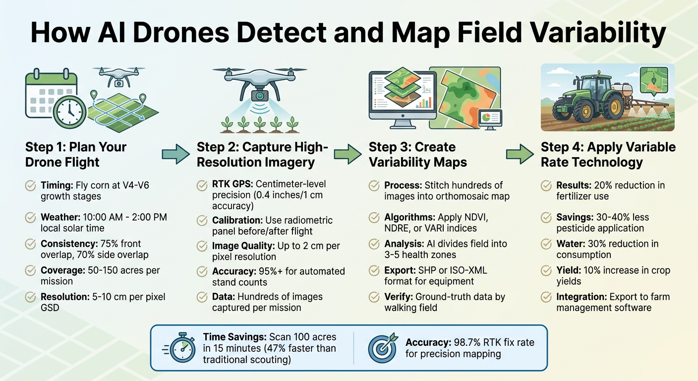
How AI Drones Detect and Map Field Variability: 4-Step Process
When it comes to creating accurate variability maps, the process extends beyond just choosing the right sensors and algorithms. The key lies in executing precise drone flights, capturing high-quality data, and systematically analyzing it. Each step builds upon the last, culminating in actionable maps that support targeted field management.
Planning Your Drone Flights
Timing is everything. For corn, aim to fly between the V4 and V6 growth stages, as this is when variability becomes both visible and manageable [10]. Consistently flying at the same growth stage every season allows you to compare data over time and assess how management strategies have impacted the field.
Weather and lighting conditions also play a huge role in data quality. Schedule flights between 10:00 a.m. and 2:00 p.m. local solar time to take advantage of high sun angles and minimize shadows [10]. Consistent cloud cover is crucial for RGB imagery analysis, as it ensures uniform lighting across the field [1].
Standardization is equally important. Stick to a consistent altitude, waypoint patterns, and camera angles. Use a 75% front overlap and 70% side overlap to ensure high-quality photogrammetry [10]. For a typical mission covering 50 to 150 acres, expect to capture hundreds of images with a Ground Sampling Distance (GSD) of 5–10 cm per pixel [3].
Capturing High-Resolution Imagery
Using RTK GPS during flights ensures centimeter-level precision, which is essential for aligning variability zones with your equipment’s guidance systems. Without RTK, prescription maps might not match actual field conditions, leading to potential misapplication of inputs.
If you're flying a multispectral mission, a radiometric calibration panel is a must. Before takeoff, place the panel in the field, capture an image of it, and repeat this process after landing. This step adjusts for changing light conditions and ensures consistent vegetation index readings across flights [10]. High-quality drones can capture imagery with a resolution as fine as 2 cm per pixel, enabling automated stand counts with an accuracy of 95% or higher [11][3].
Once the imagery is collected and calibrated, it's time to process the data into actionable maps.
Creating Variability Maps from Data
After completing your flight, import the captured images into photogrammetry software to produce a high-resolution orthomosaic map [6]. For a 100-acre field, this process may involve stitching together hundreds of multispectral images. The software aligns each image using GPS data and merges overlapping areas into a seamless, geometrically accurate map.
The next step is applying vegetation indices, which depend on your sensor type and specific goals. For general crop health monitoring, NDVI works well during early to mid-season growth. However, for dense canopies where NDVI may saturate, NDRE is more effective for detecting nitrogen deficiencies [10][3]. If you're working with a standard RGB camera, use the VARI algorithm instead, as NDVI calculations with RGB imagery are unreliable [1].
Finally, create prescription maps. AI algorithms divide the field into health zones, typically three to five categories ranging from healthy to severely stressed [6]. These maps can be exported in formats like SHP or ISO-XML, ready for use with variable-rate application equipment [10][12]. Before implementing any recommendations from the map, ground-truth the data by walking the field to confirm underlying causes of stress, such as pests, soil issues, or nutrient deficiencies [1].
Using AI Insights in Farm Management
Once you've created variability maps using drone data, the next step is to put those insights into action. AI-driven prescription maps convert raw imagery into detailed management zones, guiding decisions on where, when, and how much of each input - like fertilizer or water - to apply. This precise approach not only lowers input costs but also boosts yields across your fields.
Variable Rate Applications with Zoned Maps
Variable Rate Technology (VRT) takes AI-generated prescription maps and adjusts application rates automatically in real time. Instead of spreading the same amount of fertilizer, pesticide, or seed across the entire field, VRT ensures that each zone gets exactly what it needs. The benefits? Fertilizer use can drop by up to 20%, pesticide applications by 30–40%, and water consumption by about 30% [13]. At the same time, crop yields typically increase by around 10% [13].
To get started, you’ll need to export your variability map in a format compatible with your equipment. For example:
- Spray drones like the DJI Agras series or XAG systems use specialized formats.
- ISOBUS-compatible tractors often require Shapefiles (SHP) or RX formats [12][14].
Before deploying these maps, it’s important to verify them in the field to ensure they address the actual causes of crop stress.
AI also enhances weed detection. Unlike traditional vegetation indices like NDVI, which can't distinguish crops from weeds, AI algorithms perform "green-on-green" analysis. This allows for spot-spraying herbicides directly on weed-infested zones, minimizing waste [12]. As DJI Agriculture explains:
"Agremo's AI solution turns DJI's drone imagery into actionable insights, and its recipe maps make our AGRAS drone a truly intelligent and precise spraying tool" [12].
These advanced prescription maps integrate smoothly with farm management platforms, simplifying decision-making even further.
Farm Management Software Integration
AI insights deliver the most value when paired with your existing farm management software. Modern drone tools can import field boundaries directly from platforms like Climate FieldView™ or John Deere Operations Center, streamlining flight planning and ensuring all data stays consistent across systems [2][12]. Once your drone imagery is processed, you can export results - like stand counts, variability zones, or weed maps - back into your farm management software as data layers. This allows you to overlay drone-captured health data with historical yield and soil maps, all in one place.
For quick decisions, field-edge processing runs algorithms immediately after the drone lands, delivering results on the spot [2]. Autonomous drone missions can scout 100 acres for a stand count in just 15 minutes, cutting labor and costs by 90% compared to manual scouting [2]. When evaluating treatment effectiveness, you can map fields before and after applications to create instant side-by-side comparisons [2].
For more guidance on using these AI-driven tools, Drone Spray Pro offers tailored support to help farmers integrate drone technology into their farm management practices, maximizing efficiency and productivity.
What Farmers Need to Know Before Getting Started
By choosing appropriate technology, adhering to regulations, and understanding potential returns, farmers can use AI-powered drones to tackle field variability and improve crop outcomes. Knowing what equipment to use, meeting licensing requirements, and assessing financial benefits are key steps to making decisions that align with your farm's goals.
Selecting the Right Drone and Equipment
When it comes to drones, you'll need to decide between RGB and multispectral sensors. RGB cameras are cost-effective and provide standard visual mapping, while multispectral sensors can detect near-infrared light, helping you spot crop stress early and monitor overall plant health over time [1].
For tasks like plant counting, go for drones equipped with high-resolution imaging (0.5–1 cm per pixel GSD) and RTK GPS, which ensures precise field alignment [9]. In April 2026, MAS Seeds reported success using DJI Mavic 3 Multispectral drones with 0.5–1 cm/px resolution across 200 trial sites in Europe, Mexico, and Africa. By incorporating automated flights and image-based plant counting, they boosted trial capacity by 40% while cutting down on manual labor [9]. Boris Calvet, Manager of Drone Activities at MAS Seeds, explained:
"Subjectivity is a real liability. With manual grading, it's impossible to know the field standard until you've crossed the entire field" [9].
Some advanced drones now feature on-device AI processing, enabling real-time disease detection right in the field [8]. Keep in mind that battery expenses make up about 5–8% of per-acre operational costs [15]. Companies like Drone Spray Pro offer a variety of options, including the DJI Mavic 3 Multispectral for mapping and the DJI Matrice 4T for thermal imaging. They even provide free demonstrations in Southeast Idaho [15].
Once you’ve chosen your equipment, the next step is ensuring compliance with all necessary regulations.
Training and FAA Licensing Requirements
To operate drones for agricultural purposes, you’ll need an FAA Part 107 Commercial Drone License [15][16]. Additionally, any drone weighing over 0.55 lbs must be registered with the FAA, which costs $5 [15][16]. If you’re planning to use drones for spraying, an agricultural spray license is also required. Licensing rules vary by state, so it’s important to check with your local department of agriculture before starting operations [15][16]. For certain heavy-lift drone operations, a Class 3 Medical Certificate may also be necessary [15][16].
If navigating these requirements feels overwhelming, expert support is readily available. Drone Spray Pro, for instance, offers guidance on FAA Part 107 preparation and state-specific agricultural spray licensing [15][16]. Reaching out to your drone supplier early in the process can help you plan your timeline and ensure compliance before your first flight.
Once you’re licensed and trained, it’s time to evaluate how drones can contribute to your farm’s profitability.
Return on Investment for AI Drones
AI-powered drones can improve your bottom line by increasing efficiency, lowering costs, and boosting yields. High-capacity drones like the Talos T60X can cover 56–70 acres per hour [17][15], slashing labor costs compared to traditional ground equipment.
Precision is another major benefit. By using multispectral data to detect early signs of crop stress or irrigation issues, you can address problems before they affect your yields [15]. However, when calculating ROI, don’t forget to account for battery replacement costs, which typically range from $3,000 to $6,000 and represent a recurring expense [15].
For those just starting out, a dedicated mapping drone like the DJI Mavic 3 Multispectral is a smart first investment. It can help you create detailed prescription maps to identify field variability, laying the groundwork for more advanced systems later on. To ease the financial burden, financing options are available for qualified agricultural buyers [15]. Drone Spray Pro, which boasts a 5.0/5 star rating from 19 Google reviews, is frequently praised for its "excellent customer service" and competitive pricing for industrial equipment [15].
Conclusion
AI-powered drones are changing the game for farmers by simplifying the way they detect and manage variability in their fields. With high-resolution imagery and cutting-edge algorithms, these tools can spot crop stress, nutrient issues, and diseases long before they become visible to the naked eye. What used to take hours - or even days - of manual scouting can now be done in just 15 minutes for every 100 acres [2]. The data collected is then processed into variability maps with over 90% accuracy [19], allowing for precise input applications that target only the areas that need attention.
The benefits don’t stop at cutting input costs. In May 2025, researchers from the UF/IFAS Tropical Research and Education Center demonstrated how drones and AI could optimize nitrogen fertilizer use for floral hemp. They found that applying 100 to 150 pounds of nitrogen per acre resulted in the healthiest plants and the best yields [18]. Associate Professor Zack Brym highlighted the value of this approach:
"Technology like the use of drone imaging will help determine how much fertilizer might be needed mid-season, promoting more efficient use of resources and supporting sustainable farming practices" [18].
To make the most of this technology, start by investing in the right equipment, securing the necessary licenses, and verifying the data on the ground. If you’re ready to take the leap, companies like Drone Spray Pro (https://dronespraypro.com) offer end-to-end solutions, including equipment sales, FAA licensing assistance, and training. With the right setup, AI-powered drones can provide the insights you need to tackle field variability, cut costs, and boost productivity acre by acre. It’s time to embrace these advancements and pave the way for smarter, more efficient farming.
FAQs
Which camera do I need - RGB or multispectral?
When deciding between RGB cameras and multispectral cameras, it all comes down to what you're looking to achieve.
RGB cameras are your go-to for standard visual images. They're perfect for general field assessments, offering a straightforward view of your crops or fields.
Multispectral cameras, however, take things a step further. They analyze light across multiple bands, including areas like near-infrared. This makes them excellent for uncovering detailed insights into plant health, crop variability, or even detecting subtle issues like stress or moisture deficiencies.
If you're working in precision agriculture or need in-depth data, multispectral cameras are the way to go. But for basic inspections and visual overviews, stick with RGB cameras.
How accurate are drone variability maps without RTK GPS?
Drones without RTK GPS tend to produce variability maps that are less accurate because of positional errors. This limitation can impact their effectiveness for highly precise field management tasks. That said, they still offer meaningful insights into crop health and variability. These maps can be a helpful tool for spotting general trends across a field, even if pinpoint accuracy isn't guaranteed.
How do I turn an NDVI/NDRE map into a VRT prescription?
To craft a VRT prescription using an NDVI or NDRE map, start by creating precise, georeferenced maps with multispectral drone imagery. Next, upload these maps into a VRA tool, such as Agremo or Pix4Dfields, where you can define management zones and assign specific application rates. Once completed, export the VRA map in a format compatible with your drone or spray system. Finally, upload the map into your drone's control system to enable accurate variable-rate application.