Call or Text: +1 (208) 425-2990
Email: Sales@DroneSprayPro.com

Future of IoT in Agricultural Drones
IoT-connected agricultural drones are transforming farming by making precision agriculture more accessible and efficient. These drones combine advanced sensors, cloud-based processing, and GPS navigation to provide real-time data and actionable insights for farmers. Key benefits include:
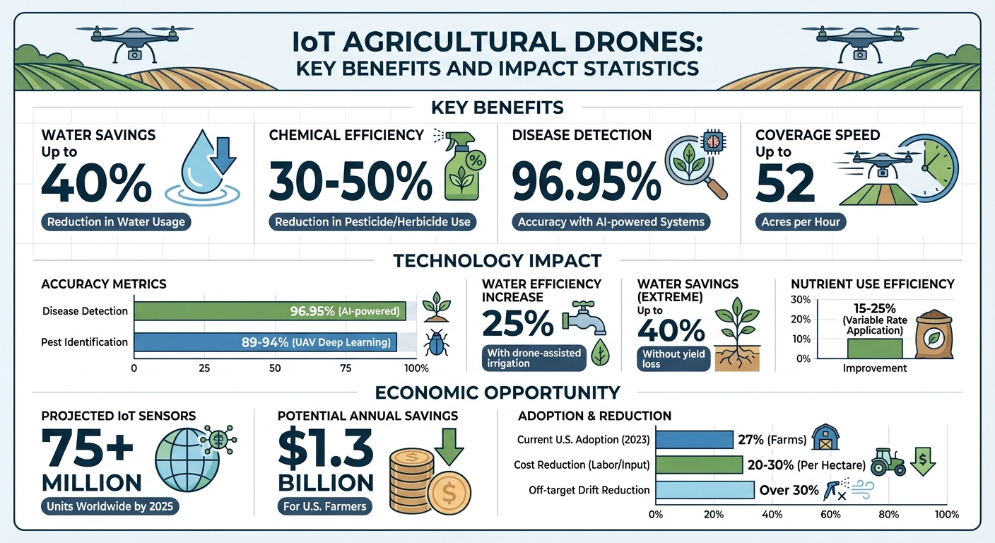
- Water Savings: Reduce water usage by up to 40%.
- Chemical Efficiency: Cut pesticide and herbicide use by 30% or more.
- Disease Detection: AI-powered systems predict crop diseases with up to 96.95% accuracy.
- Faster Operations: High-performance drones can cover up to 52 acres per hour.
- Resource Optimization: Combine aerial imagery and ground sensor data for site-specific management.
IoT drones are used for tasks like crop monitoring, variable-rate spraying, and integrating with ground-based sensors. Emerging technologies like AI-driven drone swarms, 5G connectivity, and blockchain for data security are set to further advance their capabilities. However, challenges such as FAA regulations, high infrastructure costs, and technical integration need to be addressed for widespread adoption.
Farmers can start by exploring ready-to-use drone packages with IoT features and support services to modernize their operations effectively. The future of agriculture is being shaped by these technologies, offering smarter, more precise solutions for managing crops.
IoT Agricultural Drones: Key Benefits and Statistics for Precision Farming
Agricultural IoT: Smart Farming & Precision Agriculture with Sensors and Automated Irrigation
sbb-itb-3b7eef7
Key IoT Technologies in Agricultural Drones
IoT-connected agricultural drones rely on three main technology layers: sensors for gathering data, cloud systems for processing that data, and GPS for precise navigation. These components work together to transform raw field data into actionable insights, paving the way for more efficient and effective farming.
Sensors for Data Collection
Agricultural drones are equipped with advanced multispectral sensors that go beyond visible light, capturing data to assess chlorophyll levels, plant health, and water stress. These sensors, used in over 80% of agricultural drones globally, typically capture between 4 and 10 spectral bands. By identifying issues early, they have been linked to increasing crop yields by as much as 15% [7].
For even more detailed insights, hyperspectral sensors record hundreds of continuous spectral bands, creating a unique "fingerprint" that can detect specific pests, diseases, or nutrient deficiencies. Thermal sensors add another layer by measuring temperature variations across fields, helping to identify water stress, irrigation leaks, and transpiration rates - potentially saving over 20% of water used in agriculture [7]. Additionally, LiDAR (Light Detection and Ranging) technology uses laser pulses to create highly accurate 3D terrain models, with accuracy rates between 95% and 98%. These models assist with drainage design, biomass estimation, and mapping. By 2025, it’s projected that IoT sensor installations in agriculture will exceed 75 million units worldwide [7].
The data collected by these sensors is then processed through cloud systems, turning raw information into actionable farming strategies.
Cloud Systems and Data Processing
Once the sensors gather data, cloud platforms take over to process and analyze it. These systems combine drone and ground sensor data to provide precise, site-specific recommendations. Using AI and machine learning, cloud platforms merge aerial imagery with ground-level information, offering tailored guidelines for farming operations [4].
"Precision agriculture has emerged as a transformative approach to farming, enabling data-driven decisions, resource optimization, and improved yields." - ScienceDirect [8]
Data processing happens in layers. Edge computing handles immediate tasks like avoiding obstacles and making real-time adjustments, while cloud systems manage larger tasks such as long-term data storage, historical analysis, and yield predictions [9][4]. For example, a 2024 study in Greek vineyards using the XAG P100 drone demonstrated that real-time RGB image analysis for spraying reduced pesticide use by 46% to 75%, as only targeted areas were treated [9]. Cloud-based dashboards also allow farmers to monitor water levels, air pressure, and soil moisture in near real-time, enabling quick adjustments to irrigation schedules [1][4]. Additionally, integrated UAV deep learning systems have achieved pest identification accuracy rates between 89% and 94% [9].
GPS and Location Systems
To complement sensor data and cloud analytics, high-precision GPS ensures drones operate with pinpoint accuracy in the field. Modern GPS and GNSS systems provide centimeter-level precision, which is crucial for tasks like targeted spraying and detailed field mapping [3].
"High-precision satellite navigation systems are essential for precision agricultural operations. These systems allow drones to maintain their position with centimeter-level accuracy, which is crucial for precision agricultural applications." - MDPI Drones Journal [3]
GPS technology not only enables autonomous navigation - allowing drones to follow pre-programmed flight paths with minimal human input - but also works alongside Inertial Measurement Units (IMUs) to adjust flight paths in real time, even in difficult weather. When paired with 4G or 5G networks, GPS facilitates Beyond Visual Line of Sight (BVLOS) operations, extending the range of drones for large-scale farm monitoring. Furthermore, GPS georeferences multispectral and thermal data, helping farmers locate specific areas affected by crop stress, pests, or nutrient deficiencies. In areas with limited internet access, drones can use GPS to navigate to ground-based IoT sensors, collect their data via LoRa or Wi-Fi, and return it to a central hub. This "data mule" approach helps bridge connectivity gaps in rural settings [2].
Together, these technologies form an integrated system that empowers farmers to make smarter decisions, optimize resources, and improve crop production.
How IoT-Connected Drones Are Used in Agriculture
IoT-connected drones are transforming agriculture by turning field data into actionable insights. These drones act as a bridge between ground-based sensors and cloud platforms, empowering farmers to assess field conditions and take immediate action. Their real-time capabilities are making a big impact in areas like crop monitoring, precision spraying, and sensor integration.
Real-Time Crop Monitoring
Equipped with advanced multispectral sensors and cloud-based analytics, drones are now key players in crop monitoring. As they fly over fields, multispectral cameras capture vegetation indices like NDVI (Normalized Difference Vegetation Index), which helps assess plant health. Thermal sensors identify temperature changes that could signal water stress or early pest problems, while LiDAR systems generate 3D maps of canopy structures, measuring factors like Leaf Area Index (LAI) and spotting drainage issues.
"Drones, acting as mobile data collectors and communication gateways, can enhance the performance of agricultural wireless sensor networks (WSNs)." - AgriEngineering [2]
Drones also collaborate with ground sensors that measure soil moisture, pH levels, and nutrient content. Using LoRaWAN or Wi-Fi, they relay this data to cloud platforms for near real-time analysis [1][2]. When combined with UAV-based deep learning systems, drones can identify pests with accuracy rates of 89% to 94% [9], enabling farmers to address problems within hours instead of days.
Variable Rate Application for Spraying
IoT drones like the DJI Agras T50 have redefined how fertilizers and pesticides are applied through variable rate application (VRA). This process uses a Perception-Decision-Execution (PDE) framework: sensors detect pest locations, AI determines the exact dosage required, and variable-rate nozzles deliver the treatment [9].
Pulse Width Modulation (PWM) technology allows nozzles to adjust flow rates in real time, with response times as quick as 10–50 milliseconds. Some systems even mix chemicals during flight to meet specific field needs [9]. Compared to traditional broadcast methods, VRA improves nutrient use efficiency by 15% to 25% and reduces off-target drift by over 30% [6][9].
"Precision spraying technology - integrating UAV-based detection, real-time pesticide mixing, and adaptive variable-rate spraying - provides a critical pathway for sustainable crop protection by establishing a 'perception-decision-execution' closed-loop framework." - Nature [9]
To achieve this level of precision, RTK-GPS positioning is crucial. It provides the centimeter-level accuracy needed for effective spraying operations [6].
Working with Ground-Based IoT Sensors
IoT drones also integrate seamlessly with stationary field sensors, creating a comprehensive monitoring system. While ground sensors offer continuous, location-specific readings, drones provide aerial imagery for broader spatial context. This combination produces highly accurate prescription maps [4][9].
The integration works both ways. For instance, a soil sensor detecting low moisture can automatically trigger a drone mission to locate irrigation leaks using thermal imaging [4][9]. Drones can also send wake-up signals to ground sensors, conserving battery life by prompting data transmission only when necessary [2].
This collaborative approach delivers tangible results. Drone-assisted irrigation systems paired with ground sensors can increase water efficiency by 25%, and in some cases, cut water usage by up to 40% without sacrificing yields [4]. Additionally, integrated systems can reduce labor and input costs by 20%–30% per hectare [5].
For farmers looking to adopt these technologies, Drone Spray Pro (https://dronespraypro.com) offers ready-to-use drone packages. These include advanced IoT features, FAA licensing support, training, and essential accessories - making it easier to modernize farm operations and boost crop management efficiency.
Future Developments in IoT and Agricultural Drones
Agricultural drones are on the brink of a transformation, combining AI-driven automation, improved connectivity, and secure data systems. These advancements aim to simplify farm operations and make precision agriculture more efficient for farmers across the U.S.
Autonomous Drones and AI
The next generation of drones will operate in coordinated swarms, tackling tasks like spraying and mapping without requiring human input [5][11]. Equipped with edge computing, these drones will instantly adapt to field conditions - adjusting spray levels or rerouting flight paths when they detect crop stress or pest infestations [1][6].
"Seeing these artificial intelligence (AI) and blockchain-empowered, intelligent swarms working together to accomplish human-to-machine and machine-to-machine tasks will be a possible scenario, also called the 'Blockchain of Intelligent Things.'" - IEEE [11]
RTK-GPS will deliver the pinpoint accuracy needed for navigating uneven terrain [6]. Meanwhile, AI-powered predictive tools will analyze historical and real-time IoT data to forecast irrigation needs, fertilization schedules, and pest activity. This allows drones to act before potential damage escalates [8][1]. Researchers are also exploring solar-powered drones to overcome battery limitations and extend flight durations [5].
For farmers embracing these advancements, modular drone systems - featuring interchangeable tanks for liquids or dry materials - will provide versatility for tasks like seeding, spraying, and fertilizing [6]. However, for these autonomous systems to work seamlessly, robust connectivity is essential.
5G and Better Rural Internet Access
Connectivity is still a major obstacle for drones and IoT in rural farming regions [4]. The rollout of 5G and improvements in rural internet infrastructure could create an "Internet of Drones", enabling UAVs to autonomously manage complex agricultural tasks [4].
Fast, reliable connectivity is key for Beyond Visual Line of Sight (BVLOS) operations, which are crucial for monitoring large farms [4]. With 5G, farmers can receive real-time alerts and visualize field conditions through dashboards, empowering them to respond immediately to irrigation or pest issues [4]. This level of connectivity also supports cloud, fog, and edge computing, enabling drones to process large datasets without delays caused by poor internet access [4].
| Connectivity Technology | Role in Agricultural Drone IoT | Primary Benefit |
|---|---|---|
| 5G | High-speed, low-latency data transfer | Real-time AI analytics and drone swarm coordination |
| Satellite | Global coverage for remote areas | Connectivity where cellular networks are unavailable |
| LoRaWAN | Long-range, low-power communication | Ideal for linking ground sensors to drone hubs |
| Mesh Networking | Device-to-device communication | Drones relay data across extensive fields |
While waiting for 5G to reach all rural areas, farmers can explore LoRaWAN or mesh networking as temporary solutions for basic IoT communication [4]. Drones with edge computing capabilities can also reduce reliance on unstable connections by processing data locally [4].
Blockchain for Data Security
As these technologies evolve, secure data management becomes increasingly important. Blockchain technology offers a way to safeguard drone networks and ensure data integrity. Blockchain frameworks are being developed to support Drones as a Service (DaaS), simplifying the management of UAV swarms while maintaining security [11].
This technology addresses key challenges like data confidentiality, authenticity, and route management, ensuring that data collected by drones remains untampered [11]. Blockchain also creates a transparent ledger of farming activities, improving trust in local agriculture and enhancing supply chain transparency [11][10].
"The development of the Internet of Things (IoT), Artificial intelligence, UAVs, and Blockchain technologies as new sectors has the potential to significantly improve the status of the Agricultural domain." - IEEE [10]
Drones can act as mobile gateways, using blockchain-based protocols to securely transfer data from ground sensors to cloud systems. This ensures the entire process - from data collection to action - is protected [2]. However, implementing blockchain requires careful management to balance energy usage and minimize delays in data transmission [11][2]. Together, these innovations are shaping a future where farming becomes even more precise and efficient.
Challenges and What to Consider Before Implementation
IoT-enabled agricultural drones bring plenty of potential to the table, but adopting this technology isn’t without its hurdles. Farmers need to weigh factors like regulatory compliance, infrastructure costs, and integration challenges before diving in. Addressing these upfront can save a lot of headaches (and expenses) later.
FAA Regulations and Licensing
In the U.S., operating drones for agriculture comes with a list of federal regulations that can’t be overlooked. For drones under 55 pounds, operators must secure a Remote Pilot Certificate under Part 107. This involves passing a knowledge test, undergoing TSA security checks, and renewing the certificate every two years through online training [14][15].
For heavier drones - those tipping the scales at 55 pounds or more with payload - things get more complex. These fall under Section 44807 exemptions, requiring an FAA Medical Certificate and a petition for exemption based on a risk assessment [13]. If you’re using drones for spraying pesticides, herbicides, or fertilizers, you’ll also need a Part 137 Agricultural Aircraft Operator Certificate [13][17].
Additionally, all drones must be registered with the FAA, costing $5 for three years. Since September 16, 2023, most drones must broadcast Remote ID data, detailing the aircraft's position [12][13]. For flights in controlled airspace, operators need authorization through the LAANC system and must maintain a visual line of sight unless a waiver is granted [13][14]. Tools like B4UFLY or the FAA's "Visualize It" map can help check airspace restrictions before takeoff [14].
| Requirement | Small UAS (< 55 lbs) | Heavy UAS (≥ 55 lbs) |
|---|---|---|
| Primary Regulation | 14 CFR Part 107 | Section 44807 Exemption |
| Registration Method | FAADroneZone (Online) | Paper (N-number) Process |
| Pilot Certificate | Remote Pilot Certificate | Remote Pilot Certificate + Medical Certificate |
| Dispensing Rules | Part 137 (if spraying) | Part 137 (if spraying) |
| Altitude Limit | 400 ft AGL | Specified in Exemption |
Once you’ve tackled the regulatory landscape, it’s time to evaluate the financial and technical commitments involved.
Infrastructure Costs and Technical Requirements
The cost of IoT-enabled agricultural drones goes far beyond just buying the drone itself. Entry-level scouting drones start at around $600, while intermediate models run between $5,500 and $6,000. Advanced drones, like the DJI Matrice 350 RTK, can cost upwards of $12,559 [16]. If you’re looking at heavy payload spray drones, expect an even steeper price tag.
Connectivity is another crucial factor. Systems like RTK-GPS, satellite, LoRaWAN, or mesh networks are essential for precision applications [4][6][16]. RTK-GPS, for example, delivers centimeter-level accuracy but often requires base stations or subscription services [6][16]. Add liability insurance to the list - pesticide applicators can expect to pay between $45 and $136 per month [13].
Battery life is another limitation. Most spray drones only last 5 to 20 minutes when fully loaded, so you’ll need on-site charging systems or battery-swapping stations to keep operations running smoothly [17]. Then there’s the software. Tools like DroneDeploy or PIX4D, used for map stitching and spatial analysis, come with subscription fees but are essential for turning raw aerial data into actionable insights [16].
And let’s not forget about integration.
Connecting IoT Drones with Current Farm Equipment
Getting drones to work seamlessly with existing farm systems can be tricky. The telemetry data generated by drones must align with your farm management platforms and ground-based equipment [1]. This can involve significant technical hurdles.
"While spray drones offer several benefits and are gaining popularity among consultants and growers, it is important to address that they are not meant to compete with or replace ground application equipment." - Virk et al., Auburn University [17]
Drones are excellent for pinpointing issues like weed patches or nutrient deficiencies. However, acting on this data often requires coordination with tractors, booms, and other ground equipment [1][17]. For example, variable-rate application systems on ground sprayers must be able to read and execute the prescription maps generated by drones. This might mean updating software or even retrofitting older equipment to handle precision agriculture demands [17].
Operational adjustments are also necessary. Managing tasks like syncing battery life with tank capacity, navigating airspace authorizations, and training staff to interpret IoT data can require a shift in daily routines [17]. Opting for "Ready-to-Fly" models with GPS and obstacle avoidance can make the transition easier [16]. Companies like Drone Spray Pro even offer training and FAA licensing support to help farmers get up to speed with these new tools.
While the path to adoption involves a learning curve, addressing these challenges head-on can make the investment worthwhile.
Conclusion
IoT is reshaping the role of agricultural drones, transforming them from simple aerial cameras into smart, data-driven tools seamlessly integrated with farm-wide sensor networks. Thanks to the "Perception-Decision-Execution" framework, modern drones can now detect pest threats, calculate precise chemical application needs, and perform variable-rate spraying in real-time - all with minimal human intervention [9]. This automation directly tackles challenges like rising labor costs and the growing demand for more efficient farming practices in the U.S. [6].
The impact of precision spraying is striking. It can cut pesticide use by 30% to 50% while reducing off-target drift by over 30% [9]. For U.S. farmers, this translates to potential savings of around $1.3 billion annually [18]. Yet, as of 2023, only 27% of U.S. farms had adopted precision agriculture practices [19], highlighting a significant opportunity for growth and adoption.
Looking ahead, advancements such as AI-powered drone swarms, edge computing for quicker decision-making, and enhanced 5G connectivity for beyond-visual-line-of-sight operations are poised to further enhance efficiency and scalability [5][9]. These developments could make fully autonomous, coordinated drone fleets a practical solution for large-scale farming. However, widespread adoption will depend on addressing key hurdles, including FAA compliance, infrastructure upgrades, and providing farmers with the necessary technical training.
For those ready to embrace these technologies, starting with scalable solutions is key. Companies like Drone Spray Pro offer IoT-enabled agricultural drones from trusted brands like DJI Agras, Talos, and XAG. They also provide FAA licensing assistance, hands-on training, and essential accessories like RTK dongles and battery systems. Whether you're managing hundreds or thousands of acres, adopting the right IoT-connected drone system can lead to measurable improvements in efficiency, cost savings, and environmental impact.
The future of farming is already here, taking off with IoT and drones. The real question is how quickly farmers can adapt to unlock their full potential.
FAQs
What data do IoT agricultural drones collect?
IoT agricultural drones are changing the game for modern farming by collecting a wealth of detailed data. These drones capture spatial information, multispectral images, and environmental metrics such as temperature, humidity, and soil conditions. Equipped with advanced sensors, they can also monitor crop health, detect pest infestations, and measure how resources like water and fertilizers are being used.
This rich data allows farmers to fine-tune their practices, making operations more efficient and ensuring better use of resources. It’s all about smarter farming through precise insights.
Do I need 5G for IoT-connected drone farming?
No, 5G isn’t absolutely necessary for IoT-connected drone farming. That said, it does bring some major perks. It enhances real-time communication, ensures better reliability, and provides low-latency control - all of which are crucial for autonomous drones, especially those operating beyond visual line of sight (BVLOS) or in areas where GPS signals are weak or unavailable. While other network types can handle the job, 5G stands out for its performance in these challenging conditions.
What FAA approvals do I need to spray with drones?
To legally operate drones for spraying, you’ll need two key certifications: the FAA Part 107 Remote Pilot Certificate and the Agricultural Aircraft Operator Certificate (AAOC). Additionally, you must follow FAA Part 137 regulations and obtain any required exemptions, especially if you plan to use heavier drones or conduct specialized operations.