Call or Text: +1 (208) 425-2990
Email: Sales@DroneSprayPro.com

How Crowdsourced GPS Networks Work
Crowdsourced GPS networks use data from thousands of user-operated GNSS receivers to improve positioning accuracy from meters to centimeters. These systems rely on techniques like Real-Time Kinematic (RTK) and PPP-RTK to deliver precise corrections, making them ideal for tasks like precision farming and drone navigation. Unlike traditional GPS, these networks leverage dense infrastructures of base stations and cloud-based processing to provide affordable, accurate, and real-time location data.
Key Points:
- Accuracy: Reduces GPS errors from 2–4 meters to 1–2 centimeters.
- Cost: Traditional RTK systems cost $10,000+, while crowdsourced solutions are much cheaper with monthly subscriptions (~$40).
- Applications: Used in agriculture for planting, spraying, and autonomous machinery, as well as drone operations.
- How It Works: Mobile GNSS receivers collect satellite data, which is processed in the cloud to generate correction maps. Corrections are then sent back to users in real time.
- Advantages: Eliminates the need for private base stations, offers broad coverage, and ensures reliable precision through dense station networks.
Crowdsourced GPS networks are transforming industries by making high-precision navigation accessible and cost-effective.
How Crowdsourced GPS Networks Work
Data Collection and Sharing
Mobile GNSS receivers - whether in tractors, drones, or vehicles - gather raw satellite signals, including code and phase data, while also detecting atmospheric errors [3].
This data undergoes an ambiguity test using dual base stations for validation. Once verified, it’s uploaded to a cloud server through mobile internet (3G/4G/5G) or Wi-Fi using NTRIP (Networked Transport of RTCM via Internet Protocol) [3][6]. For instance, a May 2023 experiment in Wuhan, China, tested this process with two receiver types: the geodetic-grade Trimble Net-R9 and the more affordable Septentrio Mosaic X5. These devices collected data from vehicles traveling across Wuhan’s Second and Fourth Ring Roads [3].
After being uploaded, the data is processed for real-time error corrections.
Real-Time Error Correction
On the server, user data is combined into Atmospheric Delay Correction Maps (CAM). The service area is divided into a grid (≈1 km²), and any missing data is interpolated [3]. The Wuhan study showed that creating a high-resolution atmospheric map for a large city requires just 12 MB of cloud storage [3].
Localized corrections are then sent back to users based on their grid location. This enables "RTK Fixed" mode, which delivers centimeter-level precision - an essential feature for tasks like crop spraying or navigating agricultural fields [3][6]. Some systems use Virtual Reference Station (VRS) technology, which creates a simulated base station near the user’s location to shorten baselines and improve accuracy. Nate from SparkFun explains:
NTRIP streams correction data to your rover [8].
The interaction between base stations and rovers plays a key role in applying these corrections effectively.
Base Stations vs. Rovers
Base stations are stationary GNSS receivers with known coordinates. They continuously monitor satellite signals, comparing their actual position to the satellite-determined position to identify errors in real time [6][7]. Rovers, on the other hand, are mobile devices like drones, tractors, or handheld units that receive satellite signals while also pulling correction data from the base station network [6][7].
RTK accuracy depends on distance: within 1 km, it’s around 2–3 mm, but it decreases to about 2.5 cm at 10–15 km [6]. VRS technology helps maintain accuracy of 5–10 mm even when users are 10–20 km away from a physical reference station [6]. Networks such as GEODNET, which boasts over 9,000 registered reference stations, ensure dense coverage and reliable performance [7].
Corrections are transmitted via UHF radio for short distances (3–10 km) or through NTRIP over mobile internet for longer ranges. This ensures the precision needed for applications like crop spraying and field navigation [6][8].
sbb-itb-3b7eef7
Main Components of Crowdsourced GPS Networks
GNSS Receivers and Devices
At the heart of any crowdsourced GPS network are the GNSS receivers - both base stations and rovers. These devices don’t just passively pick up satellite signals; they actively calculate atmospheric corrections, including precise ionospheric and tropospheric delay adjustments at their location [3]. A study conducted in Wuhan, China, in May 2024 tested two types of receivers: the high-end Trimble Net-R9 and the more affordable Septentrio Mosaic X5. Both devices achieved impressive dynamic positioning accuracies of 0.91–1.1 cm horizontally. This demonstrated that even budget-friendly receivers can achieve centimeter-level precision when integrated into a crowdsourced network [3].
Once these precise corrections are calculated, the data is transmitted for centralized processing.
Data Aggregation and Processing
After receiving raw observations from GNSS devices, the network processes and aggregates this data to refine correction maps. The data - including position and atmospheric details - is uploaded to a cloud server using the RTCM format. According to the LRTK Team at Lefixea Inc., RTCM acts as a "common language for conveying positioning errors" [9].
The cloud server then compiles atmospheric data from thousands of users to create Crowdsourced Atmospheric delay correction Maps (CAM). These maps divide the service area into small grids, typically 1 km × 1 km in size. Each grid requires only about 16 bytes of storage for its atmospheric attributes [3]. To fill in gaps where user data is unavailable, interpolation algorithms like LIM are used [3]. The system also employs ambiguity closure tests to validate incoming data, ensuring only reliable observations are used to update the atmospheric maps. This constant refinement benefits both the system's spatial resolution and the accuracy of user positioning [3].
Aaron Nathan, CEO of Point One Navigation, highlights the importance of data density in these networks:
The solution isn't a better algorithm. It's more data. Dense networks (30–40 km station spacing) keep both architectures in the high-reliability regime [5].
In Wuhan’s study, 97.67% of test periods had 10 or more visible satellites, providing ample data to maintain continuous updates to the CAM [3].
User Permissions and Privacy
Crowdsourced GPS networks rely on a system of two-way data exchange, where users not only receive corrections to improve their positioning but also send validated atmospheric data back to the network [3]. This process requires user consent, and devices must be configured to transmit their observations through mobile internet (3G/4G/5G) or Wi-Fi using the NTRIP protocol [3][6].
To protect privacy, all shared data is anonymized, with only position and atmospheric measurements being transmitted. Users have full control over whether their device participates in the network.
For users like farmers operating agricultural drones or precision equipment, this setup offers access to centimeter-level accuracy without the need for costly private base stations. This makes high-precision GPS technology more accessible and practical for everyday applications.
Agricultural and Drone Navigation Uses
Precision Agriculture
Crowdsourced GPS networks have transformed precision agriculture by reducing GPS error from the typical 2–4 meters down to an impressive 1–2 centimeters. This level of accuracy enables automated field mapping, precise crop monitoring, and efficient resource management [4][7].
The secret lies in a network of Continuously Operating Reference Stations (CORS), which deliver real-time corrections for issues like satellite orbit errors, clock drift, and atmospheric delays [7]. These corrections ensure that GPS data is both accurate and reliable.
Mike Horton, the creator of the GEODNET Project, highlights the role of advanced algorithms in maintaining data quality:
The AI-powered algorithms for data quality identification and integrity control play a significant role in providing high-precision correction data along with the integrity required for various applications, such as agricultural auto-steering systems [7].
Drone Navigation for Spraying
This same technology also enhances aerial applications. Agricultural spray drones equipped with Real-Time Kinematic (RTK) receivers can achieve consistent flight paths with an accuracy of 2.5 centimeters during pass-to-pass operations [4]. Such precision ensures chemicals are applied exactly where needed, eliminating waste from overlaps or untreated gaps. These drones can perform automated missions with consistent results, even across multiple flights [4].
For example, farmers using DJI Agras drones can stream RTK corrections via NTRIP directly to their remote controllers. This setup takes just 30 seconds, compared to the 10–15 minutes required for traditional base stations. With lightweight data requirements (2–5 KB/sec), even areas with limited bandwidth can support these operations, and Starlink satellite internet provides connectivity in remote locations [10].
Benefits for Farmers
The advantages of these technologies go beyond precision - they also bring cost savings and operational efficiency. Farmers can skip the hefty upfront cost of traditional base stations, which typically range from $5,000 to $8,000, by opting for a $40/month NTRIP subscription instead [10].
RTK-guided systems also simplify compliance and reporting. They automatically log the location, time, and date of all operations, creating traceable proof of treatment zones [4]. This feature not only supports regulatory requirements but also aids in the digitalization of farming. Real-time machine monitoring, streamlined regulatory reporting, and reduced input costs through more accurate spraying, seeding, and fertilizing are just a few of the practical benefits these systems offer.
Precision Agriculture Fundamentals - All You Need to Know For RTK Farming
Pros and Cons of Crowdsourced GPS Networks
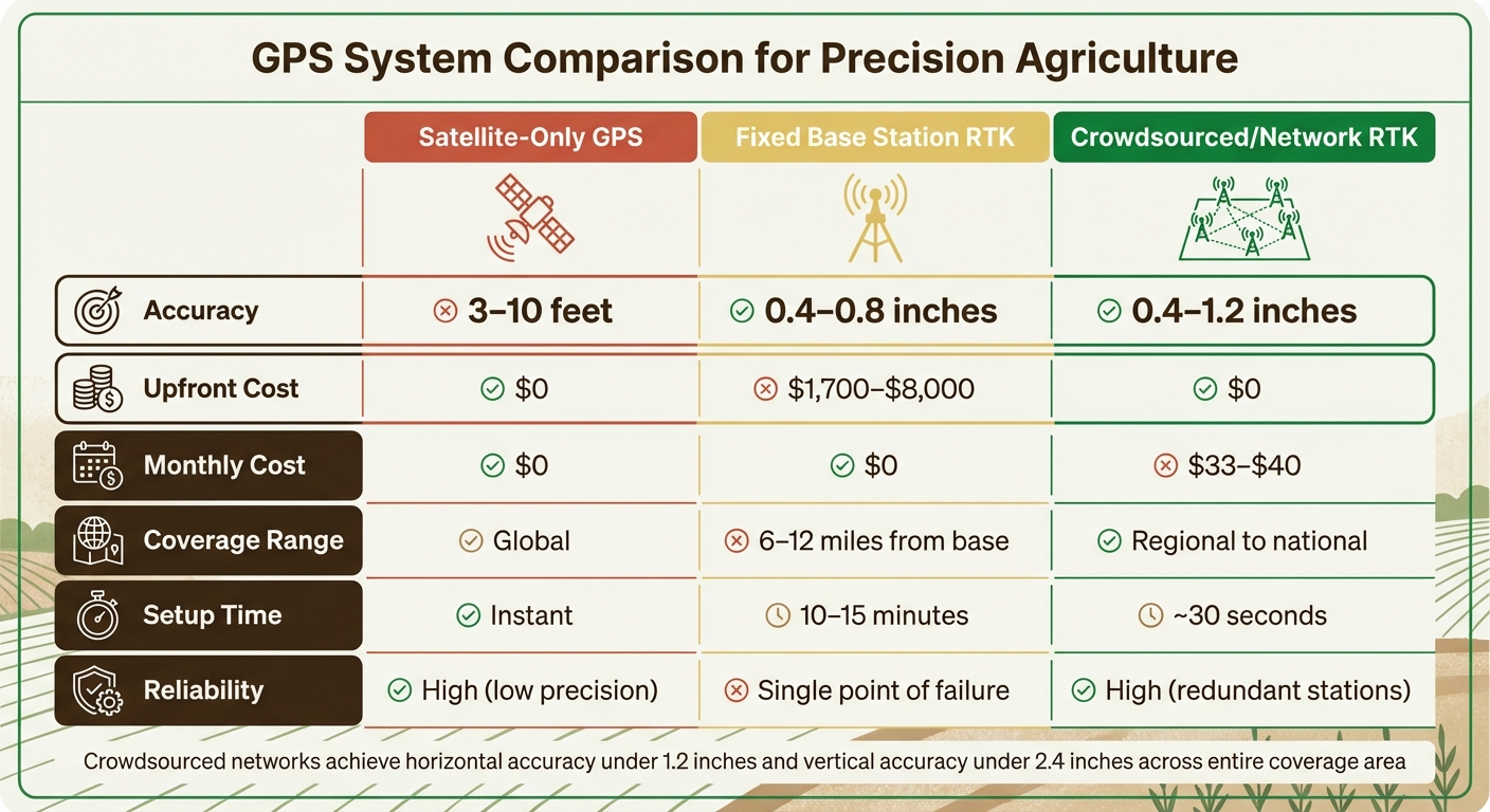
GPS System Comparison: Satellite vs RTK vs Crowdsourced Networks
Comparison with Other GPS Systems
Crowdsourced GPS networks strike a balance between cost, speed, and accuracy when compared to basic satellite positioning and dedicated RTK (Real-Time Kinematic) installations. Here's how these systems measure up:
| Metric | Satellite-Only GPS | Fixed Base Station RTK | Crowdsourced/Network RTK |
|---|---|---|---|
| Accuracy | 3–10 feet | 0.4–0.8 inches | 0.4–1.2 inches [10][11] |
| Upfront Cost | $0 | $1,700–$8,000 | $0 [10] |
| Monthly Cost | $0 | $0 | $33–$40 [10] |
| Coverage Range | Global | 6–12 miles from base | Regional to national [6][11] |
| Setup Time | Instant | 10–15 minutes | ~30 seconds [10] |
| Reliability | High (low precision) | Single point of failure | High (redundant stations) [5][11] |
This table highlights how network RTK systems, with their redundancy and regional coverage, deliver strong performance even in demanding conditions. A major benefit of crowdsourced networks is their ability to maintain accuracy through redundancy. By pulling corrections from multiple stations, they can stay precise even if one station goes offline [5][11]. As Aaron Nathan explains, dense networks ensure reliability, even when individual stations fail, providing consistent precision across large areas [5].
Modern network RTK systems achieve horizontal accuracy under 1.2 inches and vertical accuracy under 2.4 inches across their entire coverage area [11]. In contrast, traditional single-base RTK systems lose accuracy as distance increases. For example, errors can surpass 0.8 inches at 12 miles from the base [6]. Virtual Reference Station (VRS) technology addresses this issue by simulating a base station near the equipment, maintaining approximately 0.8-inch accuracy even when the nearest physical station is 30 miles away [6].
Challenges and Limitations
While crowdsourced networks offer many benefits, they also come with notable challenges. One of the most pressing issues is station density. To achieve reliable centimeter-level accuracy, base stations need to be spaced 18–25 miles apart. Sparse networks may perform well on average but can experience sudden "excursions" - unexpected jumps in error that can range from 2 to 3.5 inches [5]. For applications like precision farming, these excursions can be costly. Nathan warns:
When a system excurses 5–9 cm, that's where damage happens... A tractor drives over the crop row instead of between them [5].
Another challenge stems from atmospheric conditions. GPS signals are delayed as they pass through the ionosphere and troposphere. While models can correct for about 80% of these delays, localized disturbances require dense physical sampling to address effectively [5]. Nathan compares this to weather forecasting:
If you have weather stations every 200 km, you know the general pattern... but you can't tell whether it's raining in one neighborhood versus another [5].
Connectivity requirements also pose a hurdle, particularly for rural farmers. Crowdsourced networks rely on internet access - whether through cellular, Wi-Fi, or satellite services like Starlink - to deliver correction data [10]. Although the data demands are low (just 2–5 KB per second), connectivity gaps in remote areas can disrupt operations [10]. This can directly impact precision tasks like sprayer drones for automated crop spraying or field navigation. Farmers should thoroughly test their equipment in the field before committing to a service. Additionally, they need to ensure their equipment is compatible with the network's coordinate reference system. Most U.S. agricultural equipment uses NAD83, and mismatched settings can lead to persistent position errors [1].
Before signing up for any network service, it's crucial to request a map of physical base stations rather than relying solely on coverage area maps. The density of base stations is a far better indicator of reliability than the advertised coverage area [5].
Conclusion and Key Takeaways
Crowdsourced GPS networks are transforming precision agriculture by providing centimeter-level positioning accuracy without the hefty costs associated with traditional RTK systems. By pooling data from thousands of base stations, these networks deliver 1–2 centimeter accuracy over wide areas, making them an accessible and cost-effective solution for farmers. Instead of investing in expensive base stations, farmers can subscribe to these services and achieve comparable results.
Redundancy is another advantage. If one base station goes offline, nearby stations step in to ensure uninterrupted corrections. Real-time error corrections from these networks enhance crop spraying precision and improve machine navigation, helping farmers work more effectively.
To make the most of these services, farmers should choose providers that clearly display base station maps. Verifying station locations for proper spacing and ensuring equipment compatibility with NTRIP protocols and internet connectivity are critical steps before subscribing.
Future of Crowdsourced GPS in Agriculture
The potential for crowdsourced GPS in agriculture is immense. Take GEODNET, for example - it plans to expand its network from over 9,000 base stations today to between 50,000 and 100,000 stations worldwide by 2026 [2]. This ambitious growth is driven by blockchain-based incentives, rewarding individuals for hosting high-quality base stations. As Mike Horton explains, a denser network leads to better performance overall [2].
These networks are also branching out into dual-purpose applications. Beyond guiding tractors, the same GNSS data is being used for space weather forecasting and ionospheric monitoring, which improves atmospheric correction models. Advanced AI systems monitor signal health across thousands of stations in real time, ensuring autonomous farming equipment runs efficiently and safely.
Next Steps for Farmers
Switching to crowdsourced GPS networks doesn’t mean replacing all your current equipment. Most modern agricultural machinery and spray drones already support RTCM standards, making them compatible with these services. The key is ensuring your equipment is equipped with RTK-enabled GNSS receivers and has a stable internet connection - whether through cellular, Wi-Fi, or satellite.
For farmers in Idaho and nearby areas, Drone Spray Pro offers DJI Agras drones, RTK dongles, and other tools tailored for precision agriculture. Many providers also offer 30-day free trials of their NTRIP correction services, allowing farmers to test accuracy and signal stability in their fields before committing financially [7]. These practical steps make it easier for farmers to adopt precision GPS technology, leading to safer, more efficient, and cost-effective operations.
FAQs
What GNSS hardware do I need to use a crowdsourced RTK network?
To tap into a crowdsourced RTK network, you'll need a GNSS receiver that supports RTK positioning. This could be an RTK GNSS receiver or a compatible rover device. These tools are essential for delivering precise corrections, making them ideal for tasks like agriculture and surveying.
Will RTK still work if my farm has weak cell service or no internet?
RTK can operate even with weak cell service or no internet if you rely on a local RTK base station or use a dependable radio link. On the other hand, network RTK corrections via NTRIP usually need an internet connection to ensure real-time data transfer.
How do I check if a network has enough base station density near me?
To figure out if a correction network has enough base station density in your area, reach out to your provider and inquire about the inter-station spacing. A tightly spaced network typically leads to better correction quality, which is crucial for achieving centimeter-level accuracy. Since atmospheric errors are affected by both physical factors and how densely stations are distributed, a higher station density is usually beneficial. Make sure to confirm with your provider that the network can meet your specific requirements.