Call or Text: +1 (208) 425-2990
Email: Sales@DroneSprayPro.com

Atmospheric Effects on RTK GPS Accuracy
RTK GPS can drop from centimeter-level accuracy to inches, or even feet, when the atmosphere turns unstable. If I had to boil this article down to the main point, it’s this: space weather hurts RTK from above, and humidity hurts RTK closer to the ground.
If you use RTK on a spray drone like the DJI Agras or ABZ Innovation models, here’s what matters most:
- Ionospheric activity can cause fix loss, cycle slips, and longer convergence times.
- Tropospheric moisture can add height error and reduce repeatability, especially in humid or stormy weather.
- Longer base-to-rover distance leaves more leftover atmospheric error in the solution.
- Single-base RTK, network RTK, and PPP-RTK each handle these errors differently.
- Multi-frequency receivers help cut ionospheric interference by about 70%–80%.
A few numbers stand out:
- During ionospheric scintillation, RTK availability can fall to about 55%.
- In those same conditions, 95th-percentile horizontal error can reach 25 cm.
- During the May 10–13, 2024 geomagnetic storm, horizontal convergence and vertical convergence got much worse, with vertical convergence up 87.2% in one PPP-RTK case.
- A 1.5 mm PWV error can lead to about 1 cm of zenith delay error and about 2–3 cm of GNSS height error.
- In high humidity, RMS positioning error has been measured at 2.1x higher over a one-hour session.
Here’s the short version of what this means for you:
| Factor | What it does to RTK |
|---|---|
| Solar flares / geomagnetic storms | Can break fixed solutions and slow re-convergence |
| Humidity / water vapor | Adds delay that dual-frequency RTK can’t remove on its own |
| Long baselines | Make atmospheric mismatch between base and rover worse |
| Heavy rain / storms | Can push error from centimeters to meters |
| Multi-frequency hardware | Helps hold accuracy when conditions get rough |
So when I look at RTK performance in the field, I don’t just think about the receiver or correction source. I think about the air the signal has to pass through.
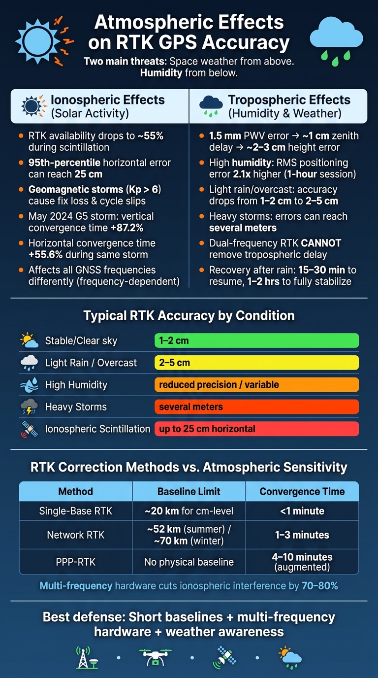
How Atmosphere Affects RTK GPS Accuracy: Key Stats & Comparisons
Ionospheric effects: solar activity and RTK instability
How solar flares and geomagnetic storms affect GPS signals
The ionosphere sits about 30 to 620 miles above Earth (50 to 1,000 km). It’s filled with charged particles, and those particles slow GNSS signals in a frequency-dependent way. Under normal conditions, RTK can correct that delay. But when solar flares or coronal mass ejections (CMEs) hit, things can go sideways fast.
These solar events bump up electron density in the ionosphere and can trigger ionospheric scintillation - fast, erratic changes in signal strength and phase. When that starts, RTK receivers may struggle to hold a fixed solution. They can lose lock, then spend time trying to re-converge. For spray drones, that can mean broken guidance and less steady pass-to-pass coverage.
Geomagnetic storms make it worse. Kp values above 6 often line up with RTK fix loss [3]. During those events, cycle slips and gross errors also rise a lot [3].
What studies show during ionospheric disturbance
Recent research puts hard numbers on the problem. During the May 10–13, 2024 geomagnetic storm - the strongest in two decades - researchers from Guizhou Normal University and Power China Guiyang Engineering Corporation reviewed data from 305 stations in Australia. They found that ionospheric delay estimate accuracy got 167.1% worse, while horizontal positioning accuracy for GPS+Galileo+BDS solutions fell by 10.4%. In that same GPS+Galileo+BDS PPP-RTK setup, horizontal convergence time went up by 55.6%, and vertical convergence time jumped by 87.2% [3].
RTK availability shows the same pattern. During scintillation, availability can drop to 55%, and 95th-percentile horizontal error can hit 25 cm [4]. Mid-latitude parts of the United States are more exposed to medium-scale traveling ionospheric disturbances (MSTIDs). These tend to show up during the day in winter and at night in summer [4].
For precision spraying, the biggest problem usually isn’t the storm by itself. It’s losing the fixed solution when you need it most.
| Metric | Quiet Ionosphere | During Disturbance |
|---|---|---|
| RTK availability | >95% | ~55% [4] |
| Horizontal error (P95, scintillation) | Centimeter-level | 25 cm [4] |
The next atmospheric limit shows up much closer to the ground, where humidity and water vapor slow RTK signals even when the weather seems calm.
sbb-itb-3b7eef7
Tropospheric effects: humidity, water vapor, and local weather
How humidity affects signal delay in the troposphere
Unlike solar-driven ionospheric errors, tropospheric delay comes from moisture and weather close to the ground. The troposphere is neutral, so it affects all GNSS frequencies in the same way. That means dual-frequency RTK can't remove this delay [8].
Tropospheric delay has two parts: a dry part and a wet part. The dry part accounts for most of the delay and is easier to model. The wet part is smaller, but it shifts fast with water vapor and local weather. And that “small” wet part can still move positions enough to matter in the field.
A precipitable water vapor (PWV) error of only 1.5 mm can cause about 1 cm of zenith tropospheric delay error. That can turn into roughly 2–3 cm of GNSS height error [2]. Light rain or overcast skies can knock RTK precision from 1–2 cm down to 2–5 cm, while heavy storms can push errors to several meters [6]. Once that starts happening, pass spacing and repeatability can drift fast.
| Condition | Typical RTK Accuracy | What's Happening |
|---|---|---|
| Stable/Clear | 1–2 cm | Base and rover see nearly the same atmosphere |
| Light Rain/Overcast | 2–5 cm | Increased signal scattering and absorption |
| High Humidity | Reduced precision | Increased moisture-related delay |
| Heavy Storms | Several meters | Severe refraction and potential signal loss |
Field data back this up. When absolute humidity climbs from 7.0 to 13.8 g/m³, RMS positioning error can increase by 2.1 times during a one-hour session [9].
Why base-to-rover distance increases tropospheric error
RTK works best when the base station and rover are looking through almost the same air. As the baseline gets longer, that idea starts to break down, and leftover tropospheric error stays in the solution [1][7].
Weather fronts, fog, irrigation moisture, and humidity gradients can all create different conditions across the same field or farm area. So even with corrections, some error remains [6]. On medium-to-long baselines, about 24 to 104 miles (38 to 167 km), the troposphere can become the main error source. The vertical part gets hit the hardest because it is tightly tied to height [10].
One study from Damao Hill, Hong Kong shows how stubborn this can be. A height difference of more than 800 meters led to a vertical RMS error of 8.6 cm with standard GPT3 modeling. A refined model, GPT3-e, cut that to 6.7 cm, a 22% drop, but that still fell short of centimeter-level performance [7].
Research also points to reference-station spacing as a big factor. For steady tropospheric interpolation, spacing is about 32 miles (52 km) in summer and 43 miles (70 km) in winter. Summer needs tighter spacing because water vapor changes more in warmer months [2]. In humid or mountainous farm areas, spacing may need to shrink all the way to 3–6 miles (5–10 km) to keep error under control [2].
Even after rain stops, the system doesn't just snap back. RTK may need 15–30 minutes to recover and 1–2 hours to fully stabilize [6]. That's why choice of RTK correction hardware matters so much when weather shifts in the middle of a spraying run.
What research says about RTK correction methods in agriculture
Single-base RTK, network RTK, and PPP-RTK in changing atmospheric conditions
The previous sections showed how the ionosphere and troposphere each chip away at RTK accuracy in their own way. What changes from one correction method to another is how much of that error is left over.
Single-base RTK uses one base station to send corrections to a rover. It works well at short distances, but once the baseline gets past about 20 km, leftover atmospheric error climbs fast. At that point, double-differencing can’t remove all of it [1][12]. In periods of high solar activity or muggy summer weather, those errors can pile up in a hurry.
Network RTK uses corrections from a CORS network made up of permanent reference stations. Research points to station spacing of about 52 km in summer and 70 km in winter to keep tropospheric interpolation error under control [2]. That said, severe ionospheric storms can throw a wrench into things. When disturbances are patchy and local, the model between stations may not catch them well, and that’s where network RTK starts to hit a wall [11].
PPP-RTK sends SSR correction data across a broad area, so it doesn’t depend on a physical baseline. The tradeoff is slower convergence. Under normal conditions, adding Global Forecast System (GFS) zenith wet delay data cuts average convergence from 10.0 minutes to 5.4 minutes, which is a 46% drop, and brings Time to First Fix down from 6.7 to 4.3 minutes [12]. But rough space weather still matters. During the May 2024 G5-level geomagnetic storm, horizontal convergence increased by 55.6% and vertical convergence by 87.2% compared with calm periods [3].
Here’s what those tradeoffs look like in field terms:
| Correction Method | Atmospheric Sensitivity | Baseline Limits | Convergence |
|---|---|---|---|
| Single-Base RTK | High - errors grow with distance | ~20 km for cm-level [1][12] | Near-instant (<1 min) |
| Network RTK | Moderate - relies on CORS interpolation | ~52 km in summer, ~70 km in winter [2] | Fast (1–3 min) |
| PPP-RTK | High - sensitive to ionospheric anomalies and ZWD | No physical baseline | 4–10 min (augmented) [12] |
One thing ties all three methods together: multi-frequency GNSS hardware. Receivers that track L1, L2, and L5 signals can cut about 70%–80% of ionospheric interference by comparing signals across frequencies [6][1]. Put plainly, no correction method can handle all atmospheric error by itself. That’s why the receiver still matters so much.
Why these findings matter for spray drones and RTK accessories
For spray drones, these differences show up in the stuff operators care about most: fix stability, convergence time, and pass-to-pass repeatability. Every onboard GNSS receiver and RTK dongle on an agricultural spray drone deals with the same atmospheric physics described in these studies. Whether your drone is using a local base station, a CORS network, or a PPP-RTK service, the system is leaning on the same kind of atmospheric modeling researchers are trying to improve.
For U.S. spray drone operators, the main takeaway is pretty simple: multi-frequency hardware gives you the best shot at holding centimeter-level precision during solar maximum and in high-humidity field conditions [6][1]. It also helps to watch space weather reports and local humidity forecasts, since those are the times when RTK accuracy is more likely to drift [6].
GNSS Accuracy Explained: From Raw Signals to Precise Positioning (RTK, PPP, GPS Deep Dive)
Conclusion: Main atmospheric risks to RTK GPS accuracy
Research points to two main RTK risks in precision agriculture: ionospheric disturbance and tropospheric delay. For sprayers, the impact shows up in practical ways - missed lines, weaker repeatability, and more time spent reacquiring position.
During strong ionospheric scintillation, errors can reach the meter level, and vertical convergence can slow sharply [3][5]. Tropospheric delay, often driven by humidity, tends to build more gradually. But it gets worse as the base-to-rover distance grows. In the field, that means one thing: when the atmosphere gets less stable, RTK gets less dependable. And when RTK drifts, pass spacing and application uniformity drift too.
For spray drone operators, the best defense is still pretty straightforward: short baselines, multi-frequency hardware, and close attention to weather conditions. For spray drones using an RTK dongle, these atmospheric limits shape every flight.
FAQs
How can I tell when RTK accuracy is about to drop?
Watch for warning signs like RTK Signal Weak, No RTK Data Available, or a system that stays stuck in Converging.
Another big red flag is when the status shifts from RTK FIX to Float mode. When that happens, accuracy can fall from centimeter-level down to about 10–30 cm.
It also helps to check PDOP. If the value is above 4.0, satellite geometry is likely poor, which can hurt position quality.
Distance matters too. Accuracy can drop when you’re working more than 30 km from the base station.
Which matters more for RTK: humidity or solar activity?
Both matter, but they don’t affect GPS in the same way.
Solar activity impacts the ionosphere. That can lead to bigger disruptions, like signal delays, scintillation, or even loss of lock. When that happens, the problem can affect large areas at once.
Humidity, on the other hand, affects the troposphere. More moisture in the air adds delay to the signal, which can chip away at positioning accuracy. It’s usually less dramatic than solar activity, but it shows up as a steady local source of error.
So the short version is simple: solar activity tends to cause larger system-wide issues, while humidity is a more consistent local problem.
What setup helps RTK stay accurate in bad weather?
Keep your drone within 12–19 miles of a local base station to cut down signal mismatch. A local base station, like the ones supported by Drone Spray Pro, usually works better than long-baseline networks when weather or solar activity throws off satellite signals.
You’ll also want a clear view of the sky, a PDOP under 4.0, and an RTK FIX before you start operations.
